Category:Bahretal
Jump to navigation
Jump to search
Urban municipalities:
Dippoldiswalde · Freital · Pirna · Sebnitz · Altenberg · Bad Gottleuba-Berggießhübel · Bad Schandau · Dohna · Glashütte · Heidenau · Hohnstein · Königstein · Liebstadt · Neustadt · Rabenau · Stolpen · Tharandt · Wehlen · Wilsdruff
Rural municipalities:
Former municipalities:
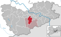
municipality in the Sächsische Schweiz-Osterzgebirge district in Saxony, Germany .JPG)   | |||||
| Upload media | |||||
| Instance of |
| ||||
|---|---|---|---|---|---|
| Location |
| ||||
| Located in or next to body of water | |||||
| Population |
| ||||
| Area |
| ||||
| Elevation above sea level |
| ||||
| official website | |||||
 | |||||
Subcategories
This category has the following 8 subcategories, out of 8 total.
Media in category "Bahretal"
The following 9 files are in this category, out of 9 total.
-
 Bahretal in PIR.svg 1,593 × 978; 326 KB
-
 BAHRETAL OTTENDORF nieder.svg 512 × 427; 21 KB
-

-

-

-

-
 Meilenblatt B 318 Liebstadt.jpg 9,000 × 9,010; 26.17 MB
-
 Meilenblatt B 319 Dohma.jpg 8,990 × 9,010; 23.56 MB
-
 Wappen Bahretal.png 556 × 599; 315 KB


