Category:Bahnhofplatz 12 (Eichstätt)
Jump to navigation
Jump to search
| Object location | | View all coordinates using: OpenStreetMap |
|---|
building in Eichstätt, Upper Bavaria, Germany  | |||||
| Upload media | |||||
| Instance of | |||||
|---|---|---|---|---|---|
| Location | Eichstätt, Upper Bavaria, Bavaria, Germany | ||||
| Street address |
| ||||
| Heritage designation | |||||
 | |||||
This is the category of the Bavarian Baudenkmal (cultural heritage monument) with the ID D-1-76-123-30 (Wikidata)
|
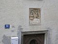
Deutsch: Bahnhofplatz 12 Eichstätt: Steilgiebelhaus, östlich der ehemaligen Fischersiedlung, Bruchstein und Fachwerkkonstruktion, im Kern Mitte 17. Jahrhundert; in Hauswand eingelassenes Kalksteinrelief mit Mariä Verkündigung, bezeichnet mit dem Jahr 1704.
Media in category "Bahnhofplatz 12 (Eichstätt)"
The following 2 files are in this category, out of 2 total.
-
 Bahnhofplatz 12 Eichstätt -D-1-76-123-30.jpg 1,024 × 768; 198 KB
-
 Bahnhofplatz 12 Eichstätt.jpg 1,536 × 2,048; 946 KB
