Category:Bahnhof Klosterfelde
Jump to navigation
Jump to search
| Object location | | View all coordinates using: OpenStreetMap |
|---|
railway station in Barnim district, Brandenburg state, Germany  | |||||
| Upload media | |||||
| Instance of | |||||
|---|---|---|---|---|---|
| Location | Klosterfelde, Wandlitz, Barnim District, Brandenburg, Germany | ||||
| Transport network | |||||
| Owned by | |||||
| Operator | |||||
| Connecting line |
| ||||
| Adjacent station |
| ||||
 | |||||
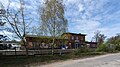
English: Pictures of the train station Klosterfelde in Klosterfelde, Wandlitz municipality, Barnim district, Brandenburg state, Germany.
Deutsch: Ansichten des Bahnhofs Klosterfelde in Klosterfelde, Gemeinde Wandlitz , Landkreis Barnim , Land Brandenburg , Deutschland.
Français : Photos de la gare Klosterfelde à Klosterfelde, commune de Wandlitz, , arrondissement de Barnim , état federé de Brandebourg , Allemagne.
Español: Vistas de la estación de ferrocarril Klosterfelde en Klosterfelde, municipio de Wandlitz, distrito de Barnim , estado federado de Brandeburgo , Alemania.
Address: Am Bahnhof 1, Klosterfelde, 16348 Wandlitz
Media in category "Bahnhof Klosterfelde"
The following 3 files are in this category, out of 3 total.
-
 Bahnhof Klosterfelde 2024 E.jpg 4,433 × 3,324; 3.56 MB
-
 Bahnhof Klosterfelde 2024 SE.jpg 3,753 × 2,110; 2.01 MB
-
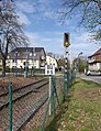 Bahnübergang Prendener Straße Klosterfelde 2024 S.jpg 2,933 × 3,808; 4.07 MB

