Category:Bagijnestraat 60, Leeuwarden
Jump to navigation
Jump to search
| Object location | | View all coordinates using: OpenStreetMap |
|---|
building in Leeuwarden, Netherlands  | |||||
| Upload media | |||||
| Instance of | |||||
|---|---|---|---|---|---|
| Location | Leeuwarden, Friesland, Netherlands | ||||
| Street address |
| ||||
| Located on street | |||||
| Heritage designation |
| ||||
 | |||||
|
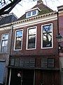
This is a category about rijksmonument number 24105
|
| Address |
|
Media in category "Bagijnestraat 60, Leeuwarden"
The following 4 files are in this category, out of 4 total.
-
 Leeuwarden Bagijnestraat 60.JPG 1,712 × 2,288; 782 KB
-
 Overzicht Bagijnestraat - Leeuwarden - 20130490 - RCE.jpg 1,200 × 1,197; 320 KB
-
 Overzicht Bagijnestraat - Leeuwarden - 20130491 - RCE.jpg 1,185 × 1,200; 307 KB
-
 Voorgevel - Leeuwarden - 20132246 - RCE.jpg 809 × 1,200; 191 KB


