Category:B6259 road (England)
Jump to navigation
Jump to search
road in England | |||||
| Upload media | |||||
| Instance of |
| ||||
|---|---|---|---|---|---|
| Location | England | ||||
| Transport network |
| ||||
| |||||

Media in category "B6259 road (England)"
The following 13 files are in this category, out of 13 total.
-
 B6259, Nateby - geograph.org.uk - 1981952.jpg 640 × 427; 276 KB
-
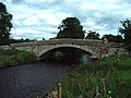 Eastfield Bridge - geograph.org.uk - 238034.jpg 640 × 480; 190 KB
-
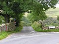
 Junction - geograph.org.uk - 238036.jpg 640 × 480; 166 KB
-
 Junction at Pendragon Castle - geograph.org.uk - 538905.jpg 640 × 480; 131 KB
-
 Moorcock Inn road junction - geograph.org.uk - 539666.jpg 640 × 480; 96 KB
-
 Road Bridge over railway - geograph.org.uk - 538935.jpg 640 × 480; 119 KB
-
 Temperance Hall, Kirkby Stephen - geograph.org.uk - 1334701.jpg 558 × 640; 136 KB
-
 The B6259 in Mallerstang - geograph.org.uk - 1271675.jpg 640 × 426; 71 KB
-
 The B6259 in Mallerstang - geograph.org.uk - 1271742.jpg 640 × 426; 81 KB
-
 The Moorcock Inn - geograph.org.uk - 5083789.jpg 1,600 × 1,170; 333 KB
-
 The Moorcock Inn at the A684-B6259 junction - geograph.org.uk - 3701286.jpg 1,024 × 683; 149 KB
-
 The Moorcock Inn on the A684 - geograph.org.uk - 3152850.jpg 800 × 600; 97 KB
-
 Kirkby Stephen road junction - geograph.org.uk - 406842.jpg 640 × 480; 122 KB


