Category:Bühlertallift Hundseck
Jump to navigation
Jump to search
| Object location | | View all coordinates using: OpenStreetMap |
|---|
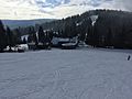
Deutsch: Am Bühlertallift Hundseck kann seit dem Winter 1970/71 Ski gefahren werden. Im Jahr 1978 wurde der zweite Schlepplift gebaut. 2006 schließlich der Panoramapavillon als Gaststätte.
Erstmals für den Winter 2011/2012 wurde eine Beschneiungsanlage gebaut. Seitdem kann im ganzen Winter Ski gefahren werden - die Webcam zeigt die Schneeverhältnisse. Flutlicht ermöglicht auch abendliches Skifahren.
Die zwei Lifte sind 560 Meter lang. Die Talstation liegt auf 890 m üNN, die Bergstation auf 1.002 m üNN. Die Abfahrt is ca. 400 m lang bzw, bei ausreichend Schnee im Wald, ist auch eine Waldabfahrten über 750 m Länge möglich.
Die Talstation des Lifts ist an der Schwarzwaldhochstrasse (B500, zwischen Sand und Hundseck), unterhalb des Berges Mehliskopf, der im Nordschwarzwald liegt.English: The Ski lift Bühlertal Hundseck is available sind 1970. The second ski lift was built in 1978, in 2006 the restaurant. Snow cannon are available since winter 2011/2012. Floodlighting is possible.
The ski lift is 560 meter long. The ski lift starts at a hight of 890 meter above sea level and gets you up to 1.002 meter - close to the top of the mountain Mehliskopf. Sking down the hill takes about 400 meter - oder 750 meter if you can ski the path through the forrest.
Media in category "Bühlertallift Hundseck"
The following 35 files are in this category, out of 35 total.
-
 Hundseck - panoramio (1).jpg 1,280 × 960; 826 KB
-
 Hundseck - panoramio (2).jpg 1,280 × 853; 863 KB
-
 Hundseck - panoramio (3).jpg 1,280 × 960; 831 KB
-
 Hundseck - panoramio (4).jpg 1,280 × 960; 829 KB
-
 Hundseck - panoramio (5).jpg 1,280 × 853; 900 KB
-
 Hundseck - panoramio (6).jpg 960 × 1,280; 993 KB
-
 Hundseck - panoramio (7).jpg 4,608 × 3,456; 3.88 MB
-
 Hundseck - panoramio.jpg 853 × 1,280; 706 KB
-
 Hundseck - Schneebar - panoramio.jpg 1,280 × 853; 734 KB
-
 Hundseck - Ski Lift - panoramio.jpg 1,280 × 853; 758 KB
-
 Hundseck - Skilift - panoramio.jpg 3,456 × 4,608; 3.97 MB
-
 Hundseck - Snow and Fun - panoramio.jpg 1,280 × 908; 852 KB
-
 Hundseck Bühlertallift 170206 01.jpg 3,264 × 2,448; 1.81 MB
-
 Hundseck Bühlertallift 170206 02.jpg 2,448 × 3,264; 2.68 MB
-
 Hundseck Bühlertallift 170206 03.jpg 3,264 × 2,448; 1.82 MB
-
 Hundseck Bühlertallift 170206 04.jpg 3,264 × 2,448; 1.78 MB
-
 Hundseck Bühlertallift 170206 05.jpg 3,264 × 2,448; 1.62 MB
-
 Hundseck Bühlertallift 170206 06.jpg 3,264 × 2,448; 1.82 MB
-
 Hundseck Bühlertallift 170206 07.jpg 3,264 × 2,448; 2.48 MB
-
 Hundseck Bühlertallift 170206 08.jpg 3,264 × 2,448; 2.4 MB
-
 Hundseck Bühlertallift 170206 09.jpg 2,448 × 3,264; 2.39 MB
-
 Hundseck Bühlertallift 170206 10.jpg 3,264 × 2,448; 2.6 MB
-
 Hundseck Bühlertallift 170206 11.jpg 3,264 × 2,448; 1.72 MB
-
 Hundseck Bühlertallift 170206 12.jpg 3,264 × 2,448; 1.95 MB
-
 Hundseck Bühlertallift 170206 13.jpg 3,264 × 2,448; 1.93 MB
-
 Hundseck Bühlertallift 170206 14.jpg 3,264 × 2,448; 2.28 MB
-
 Hundseck Bühlertallift 170206 15.jpg 3,264 × 2,448; 2.13 MB
-
 Hundseck Bühlertallift 170206 16.jpg 3,264 × 2,448; 2.31 MB
-
 Hundseck Hütte - panoramio (1).jpg 1,280 × 960; 935 KB
-
 Hundseck Hütte - panoramio (2).jpg 1,280 × 960; 892 KB
-
 Hundseck Hütte - panoramio.jpg 1,280 × 853; 860 KB
-
 Hundseckhütte an der Schwarzwaldhochstraße - panoramio.jpg 1,280 × 942; 864 KB
-
 Hundseckhütte im Schwarzwald - panoramio.jpg 960 × 1,280; 760 KB
-
 Hundsecklift - 890 m.ü.NN - panoramio.jpg 1,280 × 853; 747 KB
-
 Schneebar - Hundseck - panoramio.jpg 1,280 × 853; 736 KB
.jpg)
.jpg)
.jpg)
.jpg)
.jpg)
.jpg)
.jpg)


.jpg)
.jpg)


