Category:Bölkendorf
Jump to navigation
Jump to search
| Object location | | View all coordinates using: OpenStreetMap |
|---|
human settlement in Germany  | |||||
| Upload media | |||||
| Instance of |
| ||||
|---|---|---|---|---|---|
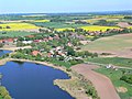
| Location | Angermünde, Uckermark District, Brandenburg, Germany | ||||
| Area |
| ||||
| Elevation above sea level |
| ||||
 | |||||
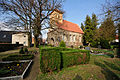
English: The village Bölkendorf belongs to Angermünde municipality, Uckermark district, Brandenburg state, Germany
Deutsch: Das Dorf Bölkendorf gehört zur Stadt Angermünde, Landkreis Uckermark, Land Brandenburg, Deutschland.
Français : Le village de Bölkendorf fait partie de la ville de Angermünde, arrondissement Uckermark, état fédéral de Brandebourg, Allemagne
Subcategories
This category has the following 2 subcategories, out of 2 total.
D
- Dorfkirche (Bölkendorf) (6 F)
N
- Naturschutzgebiet Tiefer See (2 F)
Media in category "Bölkendorf"
The following 11 files are in this category, out of 11 total.
-
 12-04-06-boelkendorf-by-RalfR-02.jpg 4,288 × 2,848; 7.29 MB
-
 12-04-06-boelkendorf-by-RalfR-04.jpg 2,848 × 4,288; 6.78 MB
-
 12-04-06-boelkendorf-by-RalfR-05.jpg 2,848 × 4,288; 3.87 MB
-
 12-04-06-boelkendorf-by-RalfR-07.jpg 2,848 × 4,288; 6.13 MB
-
 12-04-06-boelkendorf-by-RalfR-08.jpg 2,848 × 4,288; 6.17 MB
-
 12-04-06-boelkendorf-by-RalfR-09.jpg 2,848 × 4,288; 7.87 MB
-
 12-04-06-boelkendorf-by-RalfR-10.jpg 4,288 × 2,848; 8.88 MB
-
 12-04-06-boelkendorf-by-RalfR-12.jpg 4,223 × 2,790; 7.88 MB
-
 Boelkendorf 06 14 01 jiw.jpg 3,000 × 2,000; 1.79 MB
-
 Bölkendorf 05-18.jpg 2,953 × 2,215; 3.84 MB
-
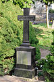
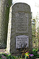
 Kriegerdenkmal Bölkendorf.jpg 2,652 × 3,891; 7.5 MB


