Category:Azerley
Jump to navigation
Jump to search
village and civil parish in North Yorkshire, United Kingdom  | |||||
| Upload media | |||||
| Instance of | |||||
|---|---|---|---|---|---|
| Location | Harrogate, North Yorkshire, Yorkshire and the Humber, England | ||||
| Population |
| ||||
| Said to be the same as | Azerley (Wikimedia duplicated page, civil parish) | ||||
 | |||||
Subcategories
This category has the following 3 subcategories, out of 3 total.
Media in category "Azerley"
The following 120 files are in this category, out of 120 total.
-
 A bridge over the River Laver - geograph.org.uk - 2524225.jpg 800 × 600; 342 KB
-
 A bridleway to the north of Azerley Park - geograph.org.uk - 2524286.jpg 800 × 600; 245 KB
-
 A footpath towards Woodhouse Farm - geograph.org.uk - 2524214.jpg 800 × 600; 331 KB
-

-
 A new roof going on at The Chequer - geograph.org.uk - 2524305.jpg 800 × 600; 258 KB
-
 A road junction near Newfield Farm - geograph.org.uk - 2524322.jpg 800 × 600; 366 KB
-
 A shady lane - geograph.org.uk - 6472800.jpg 5,147 × 3,530; 5.18 MB
-

-
 Access Track to Manor Farm - geograph.org.uk - 2932652.jpg 4,320 × 3,240; 3.43 MB
-
 Approaching Gate Bridge Road - geograph.org.uk - 4683531.jpg 1,024 × 768; 910 KB
-
 Approaching Owster Hill Farm - geograph.org.uk - 2002242.jpg 2,448 × 3,264; 2.71 MB
-
 At the junction for Kirkby Malzeard - geograph.org.uk - 6164800.jpg 3,513 × 1,873; 2.17 MB
-
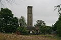 Azerley Tower - geograph.org.uk - 804690.jpg 640 × 427; 66 KB
-
 Barn at Cow Myers - geograph.org.uk - 507288.jpg 640 × 480; 88 KB
-
 Boundary Stone in Thievesgill - geograph.org.uk - 6457753.jpg 1,816 × 4,032; 2.07 MB
-
 Braithwaite Hall - geograph.org.uk - 185805.jpg 640 × 480; 92 KB
-
 Braithwaite Hall - geograph.org.uk - 466675.jpg 640 × 480; 66 KB
-
 Bridge near Galphay - geograph.org.uk - 4920353.jpg 550 × 640; 270 KB
-
 Bridleway near Frizer Hill - geograph.org.uk - 6472787.jpg 5,148 × 3,447; 3.28 MB
-
 Bridleway near Galphay - geograph.org.uk - 5879399.jpg 4,320 × 2,865; 2.66 MB
-
 Bridleway near Mickley - geograph.org.uk - 6472762.jpg 4,931 × 3,460; 4.75 MB
-
 Buildings at Galphay Mill - geograph.org.uk - 4861696.jpg 1,600 × 1,200; 715 KB
-
 Caravan site at Gold Coin Farm - geograph.org.uk - 2002250.jpg 3,178 × 1,632; 1.15 MB
-
 Cattle country - geograph.org.uk - 2002915.jpg 3,264 × 2,448; 2.03 MB
-
 Dry valley at Coal Bank - geograph.org.uk - 2933828.jpg 3,260 × 1,632; 942 KB
-
 Dry valley near Mickley - geograph.org.uk - 6472781.jpg 5,126 × 3,184; 2.93 MB
-
 Eight Acre Lane - geograph.org.uk - 804928.jpg 640 × 427; 57 KB
-
 Entrance to Azerley Chase - geograph.org.uk - 2916038.jpg 4,320 × 3,027; 2.96 MB
-
 Entrance to Five Gates Farm - geograph.org.uk - 2918847.jpg 4,320 × 3,240; 3.22 MB
-
 Entrance to Gate Bridge Farm - geograph.org.uk - 2918859.jpg 4,320 × 3,240; 3.69 MB
-
 Farm Track - geograph.org.uk - 266251.jpg 640 × 432; 135 KB
-
 Farmland - geograph.org.uk - 266271.jpg 640 × 339; 65 KB
-
 Farmland - geograph.org.uk - 266631.jpg 640 × 380; 106 KB
-
 Farmland View - geograph.org.uk - 312732.jpg 640 × 480; 99 KB
-
 Five Gates Farm - geograph.org.uk - 2524218.jpg 800 × 600; 277 KB
-
 Footpath next to the River Laver - geograph.org.uk - 312240.jpg 640 × 480; 129 KB
-
 Galphay Inn - geograph.org.uk - 1130792.jpg 640 × 447; 108 KB
-
 Galphay Mill Bridge - geograph.org.uk - 312471.jpg 640 × 480; 138 KB
-
 Galphay Mill Bridge - geograph.org.uk - 312472.jpg 640 × 480; 117 KB
-
 Galphay pinfold - geograph.org.uk - 804821.jpg 640 × 376; 86 KB
-
 Galphay village green - geograph.org.uk - 2002276.jpg 2,271 × 2,178; 894 KB
-
 Galphay Woods Farm - geograph.org.uk - 4861691.jpg 1,600 × 1,200; 593 KB
-
 Gardens by Azerley Chase.jpg 640 × 480; 120 KB
-
 Gate Bridge - geograph.org.uk - 266261.jpg 640 × 480; 145 KB
-
 Gate Bridge Mill.jpg 1,024 × 683; 198 KB
-
 Gate Bridge Road - geograph.org.uk - 266263.jpg 640 × 480; 143 KB
-
 Gate Bridge Road - geograph.org.uk - 2918852.jpg 4,320 × 3,240; 6.03 MB
-
 Gate Bridge Road joins Warren Lane - geograph.org.uk - 2524230.jpg 800 × 600; 337 KB
-
 Grewelthorpe to Mickley road - geograph.org.uk - 2281679.jpg 640 × 480; 253 KB
-
 Harvest time - geograph.org.uk - 6567420.jpg 5,184 × 3,888; 4.82 MB
-
 Hubber Lane - geograph.org.uk - 2002246.jpg 3,264 × 2,448; 1.98 MB
-
 Inscribed stone at Musterfield - geograph.org.uk - 5911921.jpg 3,239 × 4,319; 4.79 MB
-
 Junction ahead - geograph.org.uk - 5879395.jpg 3,240 × 3,538; 3.04 MB
-
 Lake at Braithwaite Hall - geograph.org.uk - 3137949.jpg 3,648 × 2,736; 3.59 MB
-
 Laver Banks Farm - geograph.org.uk - 507137.jpg 640 × 480; 74 KB
-
 Laver Banks Farm near Winksley - geograph.org.uk - 4861673.jpg 1,600 × 1,200; 498 KB
-
 Mickley main street - geograph.org.uk - 5879367.jpg 4,319 × 2,786; 2.1 MB
-
 Mickley Village - geograph.org.uk - 873611.jpg 640 × 480; 112 KB
-
 Mickley Village - geograph.org.uk - 873794.jpg 640 × 472; 105 KB
-
 Mill Farm - geograph.org.uk - 804995.jpg 640 × 427; 64 KB
-
 Mill Farm Azerley - geograph.org.uk - 3440462.jpg 1,600 × 1,063; 400 KB
-
 Mill race, Mickley - geograph.org.uk - 5879377.jpg 3,239 × 4,319; 3.8 MB
-
 Minor road junction at Old Sleningford - geograph.org.uk - 5879362.jpg 4,320 × 3,240; 2.43 MB
-
 Minor Road Junction near Azerley - geograph.org.uk - 6164774.jpg 4,119 × 1,951; 2.48 MB
-
 Missies Lane - geograph.org.uk - 2002910.jpg 2,448 × 3,264; 2.7 MB
-
 New Build at Carr House Farm - geograph.org.uk - 2584262.jpg 640 × 427; 261 KB
-
 New Footbridge - geograph.org.uk - 3138053.jpg 3,648 × 2,736; 4.91 MB
-
 New Zealand Farm - geograph.org.uk - 185993.jpg 640 × 480; 64 KB
-
 Old Boundary Stone at Old Sleningford - geograph.org.uk - 6457773.jpg 1,816 × 4,032; 2.17 MB
-
 Old Disused house - geograph.org.uk - 2935848.jpg 1,600 × 1,200; 446 KB
-
 Ordnance Survey cut benchmark - geograph.org.uk - 5401731.jpg 3,000 × 4,000; 3.29 MB
-
 Ordnance Survey Cut Mark - geograph.org.uk - 3639337.jpg 4,000 × 3,000; 4.79 MB
-
 Ornamental lake, Braithwaite Hall - geograph.org.uk - 2002256.jpg 3,264 × 2,448; 1.75 MB
-
 Path into the woods - geograph.org.uk - 2933814.jpg 2,448 × 3,264; 2.86 MB
-
 Ploughed Field - geograph.org.uk - 2584251.jpg 427 × 640; 267 KB
-
 Pond at Braithwaite Hall - geograph.org.uk - 2002264.jpg 3,111 × 1,632; 919 KB
-
 Railer Bank - geograph.org.uk - 873751.jpg 640 × 433; 87 KB
-
 Remote House - geograph.org.uk - 2240374.jpg 1,600 × 1,200; 693 KB
-
 Ripening barley near Azerley - geograph.org.uk - 6567425.jpg 5,184 × 3,888; 3.2 MB
-
 Road to Azerley - geograph.org.uk - 804975.jpg 640 × 422; 61 KB
-
 Road to Kirkby Malzead - geograph.org.uk - 2582158.jpg 640 × 427; 245 KB
-

-
 Road to Newfield - geograph.org.uk - 2584267.jpg 427 × 640; 273 KB
-
 Roadside Fence - geograph.org.uk - 2582165.jpg 427 × 640; 264 KB
-
 Ruin near the river at Mickley - geograph.org.uk - 5879388.jpg 4,320 × 3,240; 3.82 MB
-
 Sheep Pasture by The River Laver at Gate Bridge - geograph.org.uk - 6164832.jpg 4,128 × 2,006; 3.62 MB
-
 Simfield, a disintegrating farmhouse near Winksley - geograph.org.uk - 6442758.jpg 1,600 × 1,200; 408 KB
-
 Some Back Gardens in Mickley - geograph.org.uk - 2930311.jpg 640 × 480; 69 KB
-
 Storm Brewing - geograph.org.uk - 312219.jpg 640 × 432; 80 KB
-
 Stubble Field - geograph.org.uk - 2582170.jpg 427 × 640; 260 KB
-
 Temporarily Closed Road to Winksley - geograph.org.uk - 2918840.jpg 4,320 × 3,240; 3.04 MB
-
 The Galphay Inn - geograph.org.uk - 2002269.jpg 3,197 × 1,832; 1.61 MB
-
 The Lane near Windy Ridge - geograph.org.uk - 6164817.jpg 3,351 × 1,686; 2.38 MB
-
 The Main Street in Mickley - geograph.org.uk - 2930322.jpg 4,320 × 3,240; 3.7 MB
-
 The Ripon Rowel long distance path - geograph.org.uk - 912010.jpg 640 × 480; 164 KB
-

-
 The turning to Winksley - geograph.org.uk - 266259.jpg 640 × 480; 89 KB
-
 The Ure at Mickley - geograph.org.uk - 5879383.jpg 4,320 × 3,240; 3.71 MB
-
 The way to Woodhouse Farm Caravan Park - geograph.org.uk - 2521854.jpg 800 × 600; 254 KB
-
 Track Along Edge of Field - geograph.org.uk - 2584253.jpg 640 × 427; 246 KB
-
 Track to Azerley - geograph.org.uk - 2582151.jpg 427 × 640; 270 KB
-
 Track to Galphay Woods - geograph.org.uk - 266269.jpg 640 × 480; 124 KB
-
 View towards Ten Acre Plantation - geograph.org.uk - 6472795.jpg 5,127 × 3,196; 2.55 MB
-
 Warren Lane - geograph.org.uk - 6164836.jpg 3,534 × 1,358; 1.62 MB
-
 Witch of the Woods House.jpg 4,320 × 3,240; 2.45 MB
-
 Woodhouse Bridge - geograph.org.uk - 2935840.jpg 1,600 × 1,200; 720 KB
-
 Woodhouse Bridge - geograph.org.uk - 3213786.jpg 3,648 × 2,736; 1.44 MB
-
 Woodhouse Bridge - geograph.org.uk - 6164491.jpg 4,000 × 3,000; 6.65 MB
-
 Woodland at Knox Hill - geograph.org.uk - 2002912.jpg 2,448 × 3,264; 3.34 MB
-
 Woodland path - geograph.org.uk - 6472774.jpg 5,153 × 3,366; 5.29 MB
-
 Woods by Kex Beck - geograph.org.uk - 185984.jpg 640 × 480; 110 KB
-
 Burntroots Plantation - geograph.org.uk - 185990.jpg 640 × 480; 80 KB
-
 Eight Acre Wood - geograph.org.uk - 186689.jpg 640 × 480; 81 KB
-
 Ellington Banks Army Training Unit - geograph.org.uk - 185987.jpg 640 × 480; 74 KB
-
 Frizer Hill - geograph.org.uk - 186064.jpg 640 × 480; 72 KB
-

-
 Hollin Head Wood - geograph.org.uk - 185840.jpg 640 × 480; 61 KB
-
 Hubber Wood - geograph.org.uk - 185811.jpg 640 × 480; 65 KB
-
 Track near Eight Acre Wood - geograph.org.uk - 186693.jpg 640 × 480; 80 KB
-
 Western Edge of Hollin Head Wood - geograph.org.uk - 185843.jpg 640 × 480; 82 KB


