Category:Aussichtsturm Rother Kuppe
Jump to navigation
Jump to search
| Object location | | View all coordinates using: OpenStreetMap |
|---|
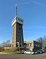
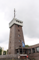
observation tower on Rother Kuppe  | |||||
| Upload media | |||||
| Instance of | |||||
|---|---|---|---|---|---|
| Location | Hausen, Rhön-Grabfeld, Lower Franconia, Bavaria, Germany | ||||
 | |||||
Media in category "Aussichtsturm Rother Kuppe"
The following 4 files are in this category, out of 4 total.
-
 Aussichtsturm Rother Kuppe 2018.jpg 4,279 × 5,383; 11.78 MB
-
 Aussichtsturm Rother Kuppe.jpg 4,673 × 3,800; 3.53 MB
-
 Aussichtsturm Rother Kuppe05062022.png 3,193 × 4,881; 19.78 MB
-
 Rother Kuppe Aussichtsturm.jpg 4,000 × 3,000; 2.88 MB


