Category:Auferstehungslinde (Annaberg-Buchholz)
Jump to navigation
Jump to search
| Object location | | View all coordinates using: OpenStreetMap |
|---|
.jpg) | |||||
| Upload media | |||||
| Instance of | |||||
|---|---|---|---|---|---|
| Location | Annaberg-Buchholz, Erzgebirgskreis, Saxony, Germany | ||||
 | |||||
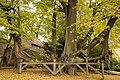
Deutsch: Naturdenkmal „Auferstehungslinde“ (Sommerlinde, Tilia platyphyllos) auf dem alten Annaberger Friedhof vor der Trinitadiskirche (Erzgebirgskreis, Sachsen).
Media in category "Auferstehungslinde (Annaberg-Buchholz)"
The following 10 files are in this category, out of 10 total.
-
 2010-12-29 Auferstehungslinde Annaberg-Buchholz (Sachsen) 01.jpg 2,594 × 3,524; 13.83 MB
-
 2010-12-29 Auferstehungslinde Annaberg-Buchholz (Sachsen) 02.jpg 3,898 × 2,594; 9.99 MB
-
 2011-01 Friedhofslinde Annaberg-Buchholz (Sachsen).jpg 2,254 × 1,500; 5.31 MB
-
 Auferstehungslinde (Annaberg-Buchholz) 03.jpg 4,480 × 6,720; 28.02 MB
-
 Auferstehungslinde (Annaberg-Buchholz) 04.jpg 6,720 × 4,480; 26.96 MB
-
 Auferstehungslinde (Annaberg-Buchholz) 05.jpg 6,720 × 4,480; 29.09 MB
-
 Auferstehungslinde (Annaberg-Buchholz) 06.jpg 6,720 × 4,480; 28.92 MB
-
 Auferstehungslinde (Annaberg-Buchholz) 07.jpg 6,720 × 4,480; 29.72 MB
-
 Auferstehungslinde (Annaberg-Buchholz) 08.jpg 6,720 × 4,480; 29.92 MB
-
 Die Gartenlaube (1884) b 472.jpg 1,668 × 1,304; 888 KB
_01.jpg)
_02.jpg)
_03.jpg)
_04.jpg)
_05.jpg)
_06.jpg)
_07.jpg)
_08.jpg)
_b_472.jpg)