Category:Auferstehungskirche (Köln-Ostheim)
Jump to navigation
Jump to search
| Object location | | View all coordinates using: OpenStreetMap |
|---|
 | |||||
| Upload media | |||||
| Instance of | |||||
|---|---|---|---|---|---|
| Location | Ostheim, Kalk, Cologne, Cologne Government Region, North Rhine-Westphalia, Germany | ||||
| Architect | |||||
| Inception |
| ||||
| Religion or worldview | |||||
 | |||||
Media in category "Auferstehungskirche (Köln-Ostheim)"
The following 5 files are in this category, out of 5 total.
-
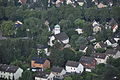
 Ballonfahrt Köln 20130810 771.JPG 4,288 × 2,848; 6.75 MB
-
 Ballonfahrt Köln 20130810 772.JPG 4,288 × 2,848; 6.94 MB
-
 Ballonfahrt Köln 20130810 773.JPG 4,288 × 2,848; 6.67 MB
-
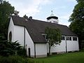 Kirche ostheim.JPG 2,848 × 2,134; 1.28 MB
-
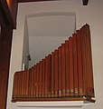 Orgel Ostheim.jpg 412 × 432; 41 KB


Categories:
- Churches in Kirchenkreis Köln-Rechtsrheinisch (Köln)
- Churches in Köln-Kalk (District)
- 1950s churches in Cologne
- Churches of the Resurrection of Christ in North Rhine-Westphalia
- Churches in North Rhine-Westphalia built in 1954
- Churches by Gerhard Langmaack
- Köln-Ostheim
- Modernist churches in Regierungsbezirk Köln