Category:Auf der Kapelle 20 (Weißenburg in Bayern)
Jump to navigation
Jump to search
| Object location | | View all coordinates using: OpenStreetMap |
|---|
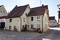
This is the category of the Bavarian Baudenkmal (cultural heritage monument) with the ID D-5-77-177-76 (Wikidata)
|
Deutsch: Weißenburg in Bayern - Auf der Kapelle 20 - Bürgerhaus. Zweigeschossiger giebelständiger Satteldachbau, Fachwerk verputzt, bez. 1770, im Kern wohl 17. Jahrhundert, kleiner Vorbau, wohl frühes 19. Jahrhundert.
building in Weißenburg in Bayern, Middle Franconia, Germany  | |||||
| Upload media | |||||
| Instance of | |||||
|---|---|---|---|---|---|
| Location | Weißenburg in Bayern, Weißenburg-Gunzenhausen, Middle Franconia, Bavaria, Germany | ||||
| Street address |
| ||||
| Heritage designation | |||||
 | |||||
Media in category "Auf der Kapelle 20 (Weißenburg in Bayern)"
The following 4 files are in this category, out of 4 total.
-
 Weißenburg in Bayern, Auf der Kapelle 20 20170901 001.jpg 6,016 × 4,016; 11.73 MB
-
 Weißenburg in Bayern, Auf der Kapelle 20-20160817-001.jpg 4,003 × 5,996; 9.09 MB
-
 Weißenburg in Bayern, Auf der Kapelle 20-20160817-002.jpg 5,996 × 4,003; 10.2 MB
-
 Weißenburg, Auf der Kapelle 20-001.jpg 4,928 × 3,264; 7.57 MB


