Category:Auckland Volcanic Field in 2010
Jump to navigation
Jump to search
Subcategories
This category has only the following subcategory.
M
Media in category "Auckland Volcanic Field in 2010"
The following 14 files are in this category, out of 14 total.
-
 Hampton Park scoria cone Auckland.jpg 2,592 × 1,944; 1.5 MB
-
 Mount hobson Auckland kumara pits.jpg 3,264 × 2,448; 2.61 MB
-
 Mount Saint John crater panorama.jpg 5,158 × 2,281; 3.11 MB
-
 Mount Wellington behind Stonefields quarry redevelopment.jpg 3,072 × 2,304; 2.25 MB
-
 Mt Mangere viewed from One Tree Hill - cropped.jpg 3,884 × 979; 944 KB
-
 One Tree Hill (6958035569).jpg 3,586 × 2,391; 2.73 MB
-
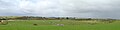 Pukaki crater panorama Auckland.jpg 4,724 × 1,200; 1,016 KB
-
 Pukeiti volcano Auckland New Zealand.jpg 2,592 × 1,944; 2.12 MB
-
 Rangitoto Island - panoramio (1).jpg 4,000 × 3,000; 4.97 MB
-
 Reservoir On Top Of Mt Wellington I.jpg 1,600 × 1,200; 1.4 MB
-
 Reservoir On Top Of Mt Wellington II.jpg 1,600 × 1,200; 1.08 MB
-
 View Over Alexandra Park To The CBD.jpg 1,600 × 1,200; 1.02 MB
-
 Wiri Mountain from McLaughlins Hill.jpg 3,264 × 2,448; 2.3 MB
-
 Wiri Mountain quarry panorama.jpg 5,528 × 2,360; 3.43 MB


.jpg)

.jpg)


