Category:Ashby Canal
Jump to navigation
Jump to search
English: The Ashby-de-la-Zouch Canal is a navigable canal. (→Ashby Canal)
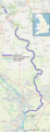
Norsk bokmål: Ashbykanalen (fullt navn Ashby-de-la-Zouch Canal) er en kanal i England, mellom Bedworth i Warwickshire og Snarestone i Leicestershire. Den er omkring 35 km lang. Tidligere gikk den omtrent 13 km lenger, til Moira rett utenfor byen Ashby-de-la-Zouch. (→Ashbykanalen)

English canal  | |||||
| Upload media | |||||
| Instance of | |||||
|---|---|---|---|---|---|
| Location | Leicestershire, East Midlands, England | ||||
| Owned by |
| ||||
| |||||
Subcategories
This category has the following 4 subcategories, out of 4 total.
Media in category "Ashby Canal"
The following 115 files are in this category, out of 115 total.
-
 A wooded stretch of the Ashby Canal - geograph.org.uk - 926538.jpg 640 × 429; 125 KB
-
 Aqueduct across the River Sence - geograph.org.uk - 931464.jpg 640 × 499; 111 KB
-
 Ashby Canal - geograph.org.uk - 1755753.jpg 1,280 × 959; 307 KB
-
 Ashby Canal - geograph.org.uk - 227076.jpg 640 × 480; 73 KB
-
 Ashby Canal and Bates Wharf Bridge - geograph.org.uk - 931492.jpg 640 × 499; 105 KB
-
 Ashby Canal and farmland - geograph.org.uk - 931504.jpg 493 × 640; 77 KB
-
 Ashby Canal and towpath - geograph.org.uk - 926600.jpg 640 × 472; 135 KB
-
 Ashby Canal and towpath - geograph.org.uk - 926620.jpg 640 × 423; 119 KB
-
 Ashby Canal and towpath - geograph.org.uk - 931498.jpg 640 × 451; 110 KB
-
 Ashby Canal aqueduct - geograph.org.uk - 931466.jpg 640 × 410; 94 KB
-
 Ashby Canal at Ashby Woulds, Leicestershire.jpg 640 × 480; 103 KB
-
 Ashby Canal at Battlefield Moorings - geograph.org.uk - 919721.jpg 640 × 459; 93 KB
-
 Ashby Canal at Marston Junction - geograph.org.uk - 227252.jpg 640 × 480; 45 KB
-

-

-
 Ashby Canal embankment - geograph.org.uk - 1753879.jpg 959 × 1,280; 485 KB
-
 Ashby Canal from Congerstone Bridge - geograph.org.uk - 925027.jpg 543 × 640; 98 KB
-
 Ashby Canal from Sutton Lane Bridge - geograph.org.uk - 918416.jpg 640 × 426; 64 KB
-
 Ashby Canal from Welsboro Bridge - geograph.org.uk - 920783.jpg 640 × 461; 72 KB
-
 Ashby Canal Map.png 565 × 1,480; 787 KB
-
 Ashby Canal near Ambion Wood - geograph.org.uk - 919690.jpg 640 × 438; 81 KB
-
 Ashby Canal near Bradfields Bridge - geograph.org.uk - 919697.jpg 587 × 640; 134 KB
-
 Ashby Canal near Carlton Bridge - geograph.org.uk - 924984.jpg 640 × 384; 79 KB
-
 Ashby Canal near Congerstone Bridge - geograph.org.uk - 925021.jpg 640 × 469; 102 KB
-
 Ashby Canal Near Congerstone UK.jpg 2,592 × 1,944; 1.27 MB
-
 Ashby Canal near Far Coton - geograph.org.uk - 922446.jpg 640 × 466; 74 KB
-
 Ashby Canal near Green Lane Bridge - geograph.org.uk - 926625.jpg 640 × 463; 138 KB
-
 Ashby Canal near Hill's Bridge - geograph.org.uk - 926566.jpg 640 × 474; 127 KB
-
 Ashby Canal near Hook's Bridge - geograph.org.uk - 920776.jpg 640 × 416; 93 KB
-
 Ashby Canal near Pare's Bridge - geograph.org.uk - 928885.jpg 640 × 453; 124 KB
-
 Ashby Canal near Shenton - geograph.org.uk - 920763.jpg 640 × 453; 110 KB
-
 Ashby Canal near Shenton Aqueduct - geograph.org.uk - 920749.jpg 640 × 536; 113 KB
-

-
 Ashby Canal near Snarestone - geograph.org.uk - 1755589.jpg 1,280 × 959; 322 KB
-
 Ashby Canal near Snarestone - geograph.org.uk - 928924.jpg 640 × 420; 69 KB
-
 Ashby Canal north of Geary's Bridge - geograph.org.uk - 918448.jpg 640 × 485; 92 KB
-
 Ashby Canal toward Pare's Bridge - geograph.org.uk - 926666.jpg 640 × 428; 97 KB
-

-
 Ashby Canal towpath - geograph.org.uk - 918431.jpg 640 × 483; 142 KB
-
 Ashby Canal viewed from Bridge 34A - geograph.org.uk - 919666.jpg 640 × 480; 81 KB
-
-
 Ashby Canal, Donisthorpe - geograph.org.uk - 60335.jpg 640 × 480; 80 KB
-
 Ashby Canal, Snareston Basin - geograph.org.uk - 1755686.jpg 1,280 × 959; 336 KB
-
 Ashby de la Zouch Canal - geograph.org.uk - 244680.jpg 640 × 480; 84 KB
-
 Ashby de la Zouch Canal, Market Bosworth - geograph.org.uk - 590417.jpg 640 × 428; 108 KB
-
 Ashby de la Zouch Canal, Market Bosworth - geograph.org.uk - 590537.jpg 640 × 428; 108 KB
-

-
 Ashby-de-la-Zouch Canal - geograph.org.uk - 1064813.jpg 640 × 480; 80 KB
-
 Ashby-de-la-Zouch Canal - geograph.org.uk - 1064821.jpg 640 × 480; 109 KB
-
 Ashby-de-la-Zouch Canal, Dadlington, Leics - geograph.org.uk - 84525.jpg 600 × 450; 256 KB
-
 Ashby-de-la-Zouche canal with bridge no.9 - geograph.org.uk - 363474.jpg 640 × 480; 100 KB
-
 AshbyCanalRouteTowardsMeasham.JPG 2,272 × 1,704; 872 KB
-
 AshbyCanalSnarestone.jpg 599 × 900; 318 KB
-
 AshbyCanalSnarestoneBridge.JPG 2,272 × 1,704; 867 KB
-
 AshbyCanalSnarestoneExtension.JPG 2,272 × 1,704; 891 KB
-

-
 Boats on the Ashby Canal, Hinckley - geograph.org.uk - 1077403.jpg 640 × 480; 76 KB
-
 Canal and Pub - geograph.org.uk - 193858.jpg 640 × 480; 64 KB
-
 Canal and road across the Sence - geograph.org.uk - 1073626.jpg 640 × 480; 115 KB
-
 Canal overflow - geograph.org.uk - 1755672.jpg 1,280 × 959; 321 KB
-
 End of the Ashby Canal - geograph.org.uk - 1755666.jpg 1,280 × 959; 312 KB
-
 Footpath in Moira, Leicestershire.jpg 640 × 480; 188 KB
-
 Footpath to the canal - geograph.org.uk - 1755644.jpg 1,280 × 959; 461 KB
-
 Former towpath in Oakthorpe and Donisthorpe, Leicestershire.jpg 640 × 480; 125 KB
-
 Ice on the Ashby Canal, Hinckley - geograph.org.uk - 1077410.jpg 640 × 480; 121 KB
-

-
 Lineage Farm and the Ashby Canal - geograph.org.uk - 924994.jpg 640 × 490; 100 KB
-
 Marston Junction - geograph.org.uk - 227082.jpg 640 × 480; 57 KB
-
 Moira Furnace and Ashby Canal - geograph.org.uk - 603807.jpg 640 × 427; 55 KB
-
 MoiraFurnace01.jpg 2,048 × 1,204; 494 KB
-
 Moorings along the Ashby Canal - geograph.org.uk - 676388.jpg 640 × 416; 77 KB
-
 Moorings at Sutton Cheney Wharf - geograph.org.uk - 918471.jpg 510 × 640; 89 KB
-
 Narrow boats - geograph.org.uk - 1407017.jpg 640 × 360; 94 KB
-
 NCN (63) near Moira Furnace.jpg 2,298 × 1,476; 663 KB
-
 Permanent narrowboat mooring - geograph.org.uk - 132718.jpg 640 × 480; 127 KB
-
 Previous route of Ashby Canal at Oakthorpe, Leicestershire.jpg 640 × 480; 49 KB
-
 Right round the bend in boats - geograph.org.uk - 1073589.jpg 640 × 480; 52 KB
-
 Sence and sensible travelling - geograph.org.uk - 1073613.jpg 640 × 480; 127 KB
-
 Snarestone Wharf - geograph.org.uk - 1755599.jpg 1,280 × 959; 368 KB
-
 Sutton Cheney Wharf - geograph.org.uk - 1069350.jpg 640 × 480; 79 KB
-
 The Ashby Canal - geograph.org.uk - 1631176.jpg 640 × 480; 62 KB
-
 The Ashby Canal at Donisthorpe, Leicestershire.jpg 640 × 480; 88 KB
-
 The Ashby Canal from Turn Bridge - geograph.org.uk - 931457.jpg 640 × 486; 79 KB
-
 The Ashby Canal near Dadlington - geograph.org.uk - 292905.jpg 640 × 480; 93 KB
-
 The first - geograph.org.uk - 369926.jpg 640 × 480; 85 KB
-
 The Lime Kilns, nr. Hinckley - geograph.org.uk - 162092.jpg 640 × 480; 86 KB
-
 Turnover bridge No.61 - geograph.org.uk - 1755604.jpg 1,280 × 959; 379 KB
-
 View from a bridge - geograph.org.uk - 363521.jpg 640 × 480; 123 KB
-
 Winding hole on the Ashby Canal - geograph.org.uk - 926503.jpg 640 × 406; 72 KB
-
 A very muddy Ashby Canal towpath - geograph.org.uk - 676396.jpg 640 × 511; 111 KB
-
 Along the Ashby Canal - geograph.org.uk - 132706.jpg 640 × 480; 102 KB
-
 Ashby Canal (Donisthorpe Terminus) - geograph.org.uk - 275132.jpg 640 × 480; 95 KB
-
 Ashby Canal - geograph.org.uk - 132692.jpg 640 × 480; 104 KB
-
 Ashby Canal - geograph.org.uk - 132699.jpg 640 × 480; 76 KB
-
 Ashby Canal and lake - geograph.org.uk - 659635.jpg 476 × 640; 114 KB
-

-
 Ashby Canal from Limekiln Bridge - geograph.org.uk - 659630.jpg 640 × 456; 78 KB
-
 Ashby Canal in Hinckley - geograph.org.uk - 659641.jpg 640 × 439; 81 KB
-
 Ashby Canal near Congerstone - geograph.org.uk - 122782.jpg 640 × 480; 78 KB
-
 Ashby Canal near Dadlington - geograph.org.uk - 675552.jpg 640 × 498; 83 KB
-
 Ashby Canal near Far Coton - geograph.org.uk - 122535.jpg 640 × 480; 153 KB
-
 Ashby Canal near Shackerstone - geograph.org.uk - 122461.jpg 640 × 480; 113 KB
-
 Ashby Canal West of Shackerstone - geograph.org.uk - 126801.jpg 640 × 432; 152 KB
-
 Ashby Canal, Hinckley - geograph.org.uk - 660563.jpg 640 × 452; 89 KB
-
 Ashby Canal, Shackerstone - geograph.org.uk - 413869.jpg 640 × 480; 73 KB
-
 Bosworth Marina - geograph.org.uk - 132747.jpg 640 × 480; 90 KB
-
 Canal boats at Sutton Wharf - geograph.org.uk - 361310.jpg 640 × 480; 83 KB
-
 Canal terminus, Moira - geograph.org.uk - 60327.jpg 640 × 480; 80 KB
-
 Farm along Ashby Canal - geograph.org.uk - 132728.jpg 640 × 480; 60 KB
-
 Public footpath along the Ashby Canal - geograph.org.uk - 670038.jpg 510 × 640; 69 KB
-
 Sleeping - geograph.org.uk - 561523.jpg 640 × 480; 104 KB
-
 South along the Ashby Canal - geograph.org.uk - 676382.jpg 640 × 433; 77 KB
-
 The Ashby Canal towards Wykin Bridge - geograph.org.uk - 669921.jpg 640 × 439; 72 KB
-
 The one and only - geograph.org.uk - 343206.jpg 640 × 480; 92 KB
-
 Willow and Canal - geograph.org.uk - 297192.jpg 640 × 480; 104 KB


_near_Moira_Furnace.jpg)


_-_geograph.org.uk_-_275132.jpg)


