Category:Ash-cum-Ridley
Jump to navigation
Jump to search
English: Ash-cum-Ridley is a civil parish in the Sevenoaks district of Kent, England. According to the 2001 census the parish had a population of 7,070. The parish includes the villagea of Ash, Hodsoll Street, New Ash Green and Ridley.
civil parish in Kent, UK | |||||
| Upload media | |||||
| Instance of | |||||
|---|---|---|---|---|---|
| Named after | |||||
| Location | Sevenoaks, Kent, South East England, England | ||||
| Population |
| ||||
 | |||||
Subcategories
This category has the following 5 subcategories, out of 5 total.
Media in category "Ash-cum-Ridley"
The following 200 files are in this category, out of 318 total.
(previous page) (next page)-
 A horse with blue ears - geograph.org.uk - 6857616.jpg 2,974 × 2,062; 2.01 MB
-
 Approaching Ash Rd - geograph.org.uk - 6651913.jpg 1,024 × 684; 318 KB
-
 Arable crop near Ash - geograph.org.uk - 6651903.jpg 1,024 × 790; 302 KB
-
 Arable field near Ash - geograph.org.uk - 6651901.jpg 1,024 × 684; 233 KB
-
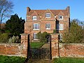 Ash Manor - geograph.org.uk - 3300928.jpg 4,000 × 3,000; 3.9 MB
-
 Ash Rd - geograph.org.uk - 6651922.jpg 1,024 × 684; 223 KB
-
 Ash Road, Ash - geograph.org.uk - 5074202.jpg 3,143 × 2,357; 1.57 MB
-
 Ashplat Wood - geograph.org.uk - 6868048.jpg 1,024 × 684; 264 KB
-
 Autumnal colours - geograph.org.uk - 6646794.jpg 1,024 × 684; 216 KB
-
 Barn on Rosemary Lane - geograph.org.uk - 3551031.jpg 640 × 430; 79 KB
-
 Barn, Ridley Court Farm - geograph.org.uk - 6882459.jpg 1,024 × 684; 231 KB
-
 Beechcroft Farm Estate - geograph.org.uk - 6646871.jpg 1,024 × 684; 162 KB
-
 Bend, New Street Rd - geograph.org.uk - 6867989.jpg 1,024 × 684; 269 KB
-
 Billet Hill - geograph.org.uk - 6651928.jpg 1,024 × 684; 291 KB
-
 Billet Hill - geograph.org.uk - 6651935.jpg 1,024 × 684; 291 KB
-
 Billet Hill - geograph.org.uk - 6651938.jpg 1,024 × 684; 271 KB
-
 Billet Hill - geograph.org.uk - 6651943.jpg 1,024 × 684; 263 KB
-
 Billet Hill - geograph.org.uk - 6651945.jpg 1,024 × 684; 292 KB
-
 Billet Hill - geograph.org.uk - 6651972.jpg 1,024 × 684; 201 KB
-
 Billet Hill, Ash - geograph.org.uk - 6769324.jpg 1,024 × 685; 407 KB
-
 Black Cottage Farm Oast - geograph.org.uk - 6867920.jpg 1,024 × 684; 224 KB
-
 Black Cottage Farm Oast - geograph.org.uk - 6867957.jpg 1,024 × 684; 166 KB
-
 Black Cottage Farm Oast - geograph.org.uk - 6867960.jpg 684 × 1,024; 166 KB
-
 Black Cottage Farmhouse - geograph.org.uk - 6867951.jpg 1,024 × 684; 202 KB
-
 Black Cottage Farmhouse - geograph.org.uk - 6867953.jpg 1,024 × 684; 143 KB
-
 Bluebells, Hall Wood - geograph.org.uk - 3611151.jpg 640 × 430; 147 KB
-
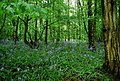 Bluebells, Hall Wood - geograph.org.uk - 3611154.jpg 640 × 430; 137 KB
-
 Bluebells, Lion Wood - geograph.org.uk - 3551025.jpg 640 × 430; 142 KB
-
 Bowdler's Well at Ridley - geograph.org.uk - 3793598.jpg 4,000 × 3,000; 4.32 MB
-
 Bowdler's Well at Ridley - geograph.org.uk - 3793606.jpg 4,000 × 3,000; 4.55 MB
-
 Bowdler's Well, Ridley - geograph.org.uk - 6882465.jpg 1,024 × 684; 283 KB
-
 Bridleway off Hodsoll Street - geograph.org.uk - 3551450.jpg 640 × 430; 134 KB
-
 Bridleway, Hodsoll Street - geograph.org.uk - 3551454.jpg 640 × 430; 102 KB
-
 Bunkers Hill - geograph.org.uk - 3322559.jpg 4,000 × 3,000; 4.07 MB
-
 Bunkers Hill - geograph.org.uk - 6882451.jpg 1,024 × 684; 229 KB
-
 Bunkers Hill, Ridley - geograph.org.uk - 5074398.jpg 3,264 × 2,448; 2.76 MB
-
 Butchers Lane - geograph.org.uk - 6646807.jpg 1,024 × 684; 254 KB
-
 Butchers Lane - geograph.org.uk - 6646820.jpg 1,024 × 684; 289 KB
-
 Butchers Lane, Ash - geograph.org.uk - 5074170.jpg 2,448 × 2,448; 1.51 MB
-
 Butchers Lane, Ash - geograph.org.uk - 5074174.jpg 2,448 × 2,448; 1.89 MB
-
 Butchers Lane, Chapel Wood Rd junction - geograph.org.uk - 6646825.jpg 1,024 × 684; 284 KB
-
 Butlers Place - geograph.org.uk - 6646876.jpg 1,024 × 684; 242 KB
-
 Butlers Place, Ash - geograph.org.uk - 5074181.jpg 2,448 × 2,448; 1.73 MB
-
 By Lion Wood - geograph.org.uk - 3551029.jpg 640 × 430; 60 KB
-
 Byway, Pettings Court Farm - geograph.org.uk - 3611139.jpg 640 × 430; 146 KB
-
 Cattle grazing - geograph.org.uk - 6875752.jpg 1,024 × 684; 168 KB
-
 Chalk dry valley - geograph.org.uk - 6882499.jpg 1,024 × 684; 229 KB
-
 Chapel Wood Rd - geograph.org.uk - 6646842.jpg 1,024 × 684; 193 KB
-
 Chapel Wood Rd - geograph.org.uk - 6646860.jpg 1,024 × 684; 211 KB
-
 Church of St Peter - geograph.org.uk - 6882452.jpg 1,024 × 684; 188 KB
-
 Church of St Peter - geograph.org.uk - 6882456.jpg 1,024 × 684; 273 KB
-
 Church of St Peter - geograph.org.uk - 6882461.jpg 1,024 × 684; 262 KB
-
 Church of St Peter - geograph.org.uk - 6882471.jpg 1,024 × 684; 288 KB
-
 Church of St Peter - geograph.org.uk - 6882472.jpg 1,024 × 684; 217 KB
-
 Church of St Peter and St Paul - geograph.org.uk - 6651875.jpg 1,024 × 684; 234 KB
-
 Church of St Peter ^ St Paul - geograph.org.uk - 6651883.jpg 684 × 1,024; 171 KB
-
 Church of St Peter ^ St Paul - geograph.org.uk - 6651889.jpg 1,024 × 684; 196 KB
-
 Church of St Peter ^ St Paul - geograph.org.uk - 6651893.jpg 685 × 1,024; 284 KB
-
 Church of St Peter ^ St Paul - geograph.org.uk - 6651899.jpg 1,024 × 684; 270 KB
-
 Churchyard, Church of St Peter ^ St Paul - geograph.org.uk - 6651880.jpg 1,024 × 684; 261 KB
-
 Clubhouse, Redlibbets Golf Club - geograph.org.uk - 6646766.jpg 1,024 × 684; 161 KB
-
 Coppiced tree - geograph.org.uk - 3611148.jpg 640 × 430; 146 KB
-
 Court View Stables - geograph.org.uk - 6875697.jpg 1,024 × 684; 161 KB
-
 Crossroads, Billet Hill - geograph.org.uk - 6651947.jpg 1,024 × 684; 298 KB
-
 Crowhurst Lane - geograph.org.uk - 6651949.jpg 1,024 × 684; 281 KB
-
 Dairy House Farm - geograph.org.uk - 3551039.jpg 640 × 430; 77 KB
-
 Dairy House Farm - geograph.org.uk - 3551413.jpg 640 × 430; 82 KB
-
 Disused chalk quarry - geograph.org.uk - 6868050.jpg 1,024 × 684; 365 KB
-
 Disused Chalk quarry, Ashplat Wood - geograph.org.uk - 6868037.jpg 1,024 × 684; 311 KB
-
 Disused drive, South Ash Manor - geograph.org.uk - 6769466.jpg 1,024 × 685; 646 KB
-
 Doves on a house at Hodsoll Street - geograph.org.uk - 6388186.jpg 3,373 × 2,529; 1.8 MB
-
 Downland scenery - geograph.org.uk - 6875733.jpg 1,024 × 684; 190 KB
-
 Ebeneezer Chapel - geograph.org.uk - 6646863.jpg 1,024 × 684; 212 KB
-
 Ebeneezer Chapel - geograph.org.uk - 6646865.jpg 1,024 × 685; 137 KB
-
 Entrance to recreation ground at New Ash Green - geograph.org.uk - 3300286.jpg 4,000 × 3,000; 4.14 MB
-
 Entrance, Church of St Peter ^ St Paul - geograph.org.uk - 6651895.jpg 1,024 × 684; 313 KB
-
 Eutrophic pond - geograph.org.uk - 6882444.jpg 1,024 × 684; 257 KB
-
 Fairseat Lane - geograph.org.uk - 6882529.jpg 684 × 1,024; 268 KB
-
 Fairseat Lane - geograph.org.uk - 6882532.jpg 1,024 × 684; 246 KB
-
 Fairseat Lane - geograph.org.uk - 6882533.jpg 684 × 1,024; 220 KB
-
 Fairseat Lane - geograph.org.uk - 6882534.jpg 1,024 × 684; 231 KB
-
 Fairseat Lane junction - geograph.org.uk - 6882524.jpg 1,024 × 684; 237 KB
-
 Farm buildings, Rosemary Lane - geograph.org.uk - 3551033.jpg 640 × 430; 83 KB
-
 Farmland - geograph.org.uk - 6867917.jpg 1,024 × 684; 188 KB
-
 Farmland and woodland - geograph.org.uk - 3551028.jpg 640 × 430; 62 KB
-
 Farmland near Hodsoll Street - geograph.org.uk - 3611129.jpg 640 × 430; 61 KB
-
 Farmland, Pettings Court Farm - geograph.org.uk - 3611142.jpg 640 × 430; 77 KB
-
 Field alongside Dunmery Grove - geograph.org.uk - 3322412.jpg 4,000 × 3,000; 4.13 MB
-
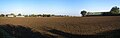 Field and barn by New Street Road - geograph.org.uk - 5942781.jpg 7,157 × 2,240; 3.05 MB
-
 Field by Church Road - geograph.org.uk - 3127620.jpg 640 × 480; 153 KB
-
 Field by Church Road - geograph.org.uk - 3127624.jpg 640 × 480; 95 KB
-
 Field by Hartley Bottom Road - geograph.org.uk - 3127569.jpg 640 × 480; 84 KB
-
 Field edge footpath - geograph.org.uk - 6875738.jpg 1,024 × 684; 252 KB
-
 Field near Ash - geograph.org.uk - 6651859.jpg 1,024 × 684; 237 KB
-
 Field near Ash - geograph.org.uk - 6651867.jpg 1,024 × 684; 228 KB
-
 Field near Ash - geograph.org.uk - 6651910.jpg 1,024 × 685; 195 KB
-
 Field near Ash - geograph.org.uk - 6651911.jpg 1,024 × 684; 221 KB
-
 Field next to Manor Lane - geograph.org.uk - 3181256.jpg 4,000 × 3,000; 3.9 MB
-
 Field Rd - geograph.org.uk - 6867987.jpg 1,024 × 684; 216 KB
-
 Footpath across field - geograph.org.uk - 6882500.jpg 1,024 × 684; 246 KB
-
 Footpath along a fence - geograph.org.uk - 3551418.jpg 640 × 430; 74 KB
-
 Footpath along field edge - geograph.org.uk - 6875730.jpg 1,024 × 684; 272 KB
-
 Footpath at Fairseat Lane - geograph.org.uk - 3321718.jpg 4,000 × 3,000; 4.1 MB
-
 Footpath at Hodsoll Street - geograph.org.uk - 3551439.jpg 640 × 430; 123 KB
-
 Footpath crossing field - geograph.org.uk - 6875728.jpg 1,024 × 684; 212 KB
-
 Footpath crossing field - geograph.org.uk - 6882496.jpg 1,024 × 684; 233 KB
-
 Footpath entering Hodsoll Street - geograph.org.uk - 3551420.jpg 640 × 430; 121 KB
-
 Footpath entering Lion Wood - geograph.org.uk - 3551020.jpg 640 × 430; 121 KB
-
 Footpath from Hartley Bottom Road - geograph.org.uk - 3298246.jpg 4,000 × 3,000; 4.32 MB
-
 Footpath in Lion Wood - geograph.org.uk - 3551022.jpg 640 × 430; 131 KB
-
 Footpath junction - geograph.org.uk - 6875731.jpg 1,024 × 684; 272 KB
-
 Footpath leading away from Fairseat Lane - geograph.org.uk - 3321710.jpg 4,000 × 3,000; 3.9 MB
-
 Footpath leading to recreation ground at New Ash Green - geograph.org.uk - 3300355.jpg 4,000 × 3,000; 4.04 MB
-
 Footpath near New Street Farm - geograph.org.uk - 3322582.jpg 3,000 × 4,000; 4.18 MB
-
 Footpath off Idleigh Court Rd - geograph.org.uk - 6875695.jpg 1,024 × 684; 223 KB
-
 Footpath off New Street Rd - geograph.org.uk - 6868008.jpg 1,024 × 684; 309 KB
-
 Footpath off Rectory Rd - geograph.org.uk - 6882436.jpg 684 × 1,024; 332 KB
-
 Footpath off Rectory Rd - geograph.org.uk - 6882441.jpg 1,024 × 684; 187 KB
-
 Footpath off Rectory Rd - geograph.org.uk - 6882470.jpg 1,024 × 684; 195 KB
-
 Footpath off Shipley Hills Rd - geograph.org.uk - 6875689.jpg 1,024 × 684; 263 KB
-
 Footpath through paddocks - geograph.org.uk - 6867930.jpg 1,024 × 684; 241 KB
-
 Footpath to Ash church - geograph.org.uk - 6646897.jpg 1,024 × 684; 313 KB
-
 Footpath to Ash church - geograph.org.uk - 6651855.jpg 1,024 × 684; 258 KB
-
 Footpath to Ash Rd - geograph.org.uk - 6651907.jpg 1,024 × 684; 319 KB
-
 Footpath to Fairseat - geograph.org.uk - 3611168.jpg 640 × 430; 154 KB
-
 Footpath to Johnson's Farm - geograph.org.uk - 6646797.jpg 1,024 × 684; 296 KB
-
 Footpath to Rectory Rd - geograph.org.uk - 6875735.jpg 1,024 × 684; 260 KB
-
 Footpath to Ridley - geograph.org.uk - 3322405.jpg 4,000 × 3,000; 4.28 MB
-
 Footpath to White Ash Wood - geograph.org.uk - 3322408.jpg 4,000 × 3,000; 3.88 MB
-
 Footpath waymarker, Haven Hill - geograph.org.uk - 6882515.jpg 1,024 × 684; 302 KB
-
 Footpath, Grubb Wood - geograph.org.uk - 6875742.jpg 1,024 × 684; 347 KB
-
 Footpath, Johnsons Farm - geograph.org.uk - 6646801.jpg 1,024 × 684; 303 KB
-
 Footpath, Redlibbets Golf Course - geograph.org.uk - 6646793.jpg 1,024 × 684; 209 KB
-
 Footpath, Redlibbets Wood - geograph.org.uk - 6646751.jpg 1,024 × 684; 318 KB
-
 Gates, Culverstone Manor Farm - geograph.org.uk - 5168643.jpg 640 × 428; 125 KB
-
 Glebe House - geograph.org.uk - 6882446.jpg 1,024 × 684; 218 KB
-
 Granary, Ridley Court Farm - geograph.org.uk - 6882463.jpg 1,024 × 684; 220 KB
-
 Gravesend Road, Vigo Village - geograph.org.uk - 5174467.jpg 2,304 × 1,728; 872 KB
-
 Green at Hodsoll Street - geograph.org.uk - 6857537.jpg 3,037 × 2,279; 2.24 MB
-
 Grubb Wood - geograph.org.uk - 6875744.jpg 1,024 × 684; 290 KB
-
 Hall Wood - geograph.org.uk - 3611141.jpg 640 × 430; 85 KB
-
 Hartley Bottom Road - geograph.org.uk - 3127570.jpg 640 × 480; 114 KB
-
 Hartley Bottom Road - geograph.org.uk - 3322393.jpg 4,000 × 3,000; 4.08 MB
-
 Hartley Bottom Road looking towards Cuckolds Corner - geograph.org.uk - 3298231.jpg 4,000 × 3,000; 4.13 MB
-
 Hartley Bottom Road, near Hartley - geograph.org.uk - 5073203.jpg 3,264 × 2,448; 2.01 MB
-
 Hartley Bottom Road, near New Ash Green - geograph.org.uk - 5073208.jpg 3,264 × 2,448; 2.52 MB
-
 Hartley Bottom Road, near Ridley - geograph.org.uk - 5074340.jpg 3,264 × 2,448; 2.2 MB
-
 Haven Hill - geograph.org.uk - 3321674.jpg 4,000 × 3,000; 4.42 MB
-
 Haven Hill - geograph.org.uk - 3322506.jpg 4,000 × 3,000; 4.38 MB
-
 Haven Hill - geograph.org.uk - 6882508.jpg 1,024 × 684; 251 KB
-
 Haven Hill - geograph.org.uk - 6882509.jpg 1,024 × 684; 213 KB
-
 Haven Hill - geograph.org.uk - 6882513.jpg 684 × 1,024; 265 KB
-
 Haven Hill - geograph.org.uk - 6882519.jpg 1,024 × 684; 277 KB
-
 Haven Hill, near Ridley - geograph.org.uk - 5074334.jpg 3,264 × 2,448; 2.39 MB
-
 Hawthorn and buttercups - geograph.org.uk - 6857611.jpg 3,200 × 2,400; 3.3 MB
-
 Hawthorn and buttercups - geograph.org.uk - 6857614.jpg 2,965 × 2,223; 2.14 MB
-
 Hawthorn near Elbows Wood - geograph.org.uk - 6857622.jpg 3,200 × 2,400; 3.12 MB
-
 Hillside Cottage - geograph.org.uk - 6882520.jpg 1,024 × 684; 227 KB
-
 Hodsoll Street - geograph.org.uk - 3551442.jpg 640 × 430; 81 KB
-
 Hodsoll Street - geograph.org.uk - 3551445.jpg 640 × 430; 108 KB
-
 Hodsoll Street - geograph.org.uk - 3551451.jpg 640 × 430; 105 KB
-
 Hodsoll Street - geograph.org.uk - 3611126.jpg 640 × 430; 63 KB
-
 Hodsoll Street Village Hall - geograph.org.uk - 3551441.jpg 640 × 430; 90 KB
-
 Hodsoll Street, near Wrotham - geograph.org.uk - 2087563.jpg 3,488 × 2,616; 2.27 MB
-
 Holywell Farmhouse - geograph.org.uk - 3793539.jpg 4,000 × 3,000; 4.2 MB
-
 Holywell Park Farm - geograph.org.uk - 3551416.jpg 640 × 430; 85 KB
-
 Home Farm House - geograph.org.uk - 3551453.jpg 640 × 430; 123 KB
-
 Honeypot Lane - geograph.org.uk - 3611145.jpg 640 × 430; 97 KB
-
 Honeypot Lane - geograph.org.uk - 3611147.jpg 640 × 430; 148 KB
-
 Honeysuckle next to a footpath at Hodsoll Street - geograph.org.uk - 6857604.jpg 3,200 × 2,400; 3.09 MB
-
 Horns Lodge - geograph.org.uk - 6882527.jpg 1,024 × 684; 223 KB
-
 Horse in a field - geograph.org.uk - 3551417.jpg 640 × 430; 78 KB
-
 Horse paddock - geograph.org.uk - 6646739.jpg 1,024 × 684; 184 KB
-
 Horses by Idleigh Court - geograph.org.uk - 3298288.jpg 4,000 × 3,000; 4.1 MB
-
 Horses grazing - geograph.org.uk - 6868021.jpg 1,024 × 684; 177 KB
-
 Idleigh Court - geograph.org.uk - 6875694.jpg 1,024 × 685; 232 KB
-
 Idleigh Court Rd - geograph.org.uk - 6875696.jpg 1,024 × 684; 289 KB
-
 Idleigh Court Rd - geograph.org.uk - 6875722.jpg 1,024 × 684; 316 KB
-
 Idleigh Court Rd - geograph.org.uk - 6875723.jpg 1,024 × 684; 252 KB
-
 Idleigh Court Rd, New Street Rd junction - geograph.org.uk - 6875699.jpg 1,024 × 684; 246 KB
-
 Idleigh Court Road - geograph.org.uk - 3298265.jpg 4,000 × 3,000; 4.11 MB
-
 Idleigh Court Road by Idleigh Court - geograph.org.uk - 3298270.jpg 4,000 × 3,000; 4.18 MB
-
 Idleigh Court Road, near Meopham - geograph.org.uk - 5073205.jpg 3,264 × 2,448; 2.49 MB
-
 Idleigh Court Road, near Meopham - geograph.org.uk - 5074611.jpg 3,264 × 2,448; 2.44 MB
-
 Industrial park off Michaels Lane - geograph.org.uk - 2074112.jpg 640 × 428; 91 KB
-
 Interior of St Peter's Church, Ridley - geograph.org.uk - 6387905.jpg 4,000 × 3,000; 4.66 MB
-
 Interior of St Peter's Church, Ridley - geograph.org.uk - 6387906.jpg 3,901 × 2,925; 2 MB
-
 Johnson's Farmhouse (geograph 6646817).jpg 1,024 × 685; 157 KB
-
 Jub's Hill Wood - geograph.org.uk - 6882497.jpg 1,024 × 684; 216 KB
-
 Jub's Hill Wood - geograph.org.uk - 6882517.jpg 1,024 × 684; 204 KB
-
 Jub's Hill Wood - geograph.org.uk - 6882522.jpg 1,024 × 684; 152 KB
-
 Kissing gate, Rosemary Lane - geograph.org.uk - 3551036.jpg 640 × 430; 118 KB
-
 Lake on London Golf Course - geograph.org.uk - 4175508.jpg 640 × 430; 70 KB
-
 Lambardes, New Ash Green - geograph.org.uk - 2916808.jpg 640 × 427; 187 KB
-
 Lion Wood - geograph.org.uk - 3551024.jpg 640 × 430; 153 KB
-
 Lion Wood - geograph.org.uk - 3551026.jpg 640 × 430; 143 KB
-
 Lion Wood - geograph.org.uk - 3551030.jpg 640 × 430; 59 KB
-
 Maize - geograph.org.uk - 6875749.jpg 1,024 × 684; 229 KB
-
 Manor Forstal - geograph.org.uk - 2362095.jpg 640 × 428; 108 KB
-
 Meadow - geograph.org.uk - 6875740.jpg 1,024 × 684; 274 KB


.jpg)


