Category:Arrowe Country Park lake footbridge
Jump to navigation
Jump to search
| Object location | | View all coordinates using: OpenStreetMap |
|---|
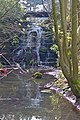
Carries an unnamed footpath across the weir at the north end of Arrowe Country Park.
Media in category "Arrowe Country Park lake footbridge"
The following 3 files are in this category, out of 3 total.
-
 Arrowe Park lake footbridge.jpg 5,087 × 3,421; 22.38 MB
-
 Bridge at Arrowe Country Park lake.jpg 4,461 × 3,384; 13.03 MB
-
 Weir and Arrowe Park lake footbridge.jpg 3,462 × 5,198; 27.85 MB


