Category:Argyle Street bridge, Birkenhead
Jump to navigation
Jump to search
| Object location | | View all coordinates using: OpenStreetMap |
|---|
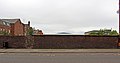
Carries Argyle Street over the disused Birkenhead Dock Branch of the Birkenhead and Chester Railway.
Media in category "Argyle Street bridge, Birkenhead"
The following 5 files are in this category, out of 5 total.
-
 Argyle Street bridge, Birkenhead 1.jpg 4,892 × 2,420; 4.33 MB
-
 Argyle Street bridge, Birkenhead 2.jpg 4,960 × 3,308; 6.43 MB
-
 Argyle Street bridge, Birkenhead 3.jpg 5,032 × 2,628; 5.59 MB
-
 Argyle Street bridge, Birkenhead 4.jpg 4,952 × 2,524; 5.33 MB
-
 Benchmark on Argyle Street bridge, Birkenhead.jpg 3,114 × 4,908; 8.91 MB


