
Category:Antrobus
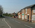
English: Antrobus is a civil parish and village in Cheshire, England, immediately to the south of Warrington. It is situated within the unitary authority of Cheshire West and Chester.
village and civil parish in Cheshire, United Kingdom  | |||||
| Upload media | |||||
| Instance of | |||||
|---|---|---|---|---|---|
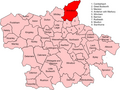
| Location | Cheshire West and Chester, Cheshire, North West England, England | ||||
| Population |
| ||||
 | |||||
Media in category "Antrobus"
The following 133 files are in this category, out of 133 total.
-
 A load of trouble^ - geograph.org.uk - 7094160.jpg 4,721 × 3,137; 3.99 MB
-
 A pond by Antrobus Golf Course - geograph.org.uk - 4424163.jpg 4,473 × 2,977; 7.94 MB
-
 A water hazard on Antrobus Golf Course - geograph.org.uk - 4424114.jpg 4,592 × 3,056; 6.55 MB
-
 A watery end - geograph.org.uk - 7094184.jpg 4,174 × 2,938; 3.73 MB
-
 A559 looking south - geograph.org.uk - 3170051.jpg 640 × 480; 74 KB
-
 Ancient Trees - geograph.org.uk - 7093257.jpg 4,128 × 2,980; 3.72 MB
-
 Antrobus - geograph.org.uk - 4261960.jpg 3,888 × 2,169; 1.89 MB
-
 Antrobus Arms - geograph.org.uk - 4070940.jpg 1,000 × 750; 126 KB
-
 Antrobus Community Shop - geograph.org.uk - 3165371.jpg 640 × 360; 227 KB
-
 Antrobus Golf Course - geograph.org.uk - 4424134.jpg 4,592 × 3,056; 6.36 MB
-
 Antrobus Hall - geograph.org.uk - 4261966.jpg 3,887 × 2,269; 1.59 MB
-
 Antrobus Soul Cakers.jpg 900 × 600; 322 KB
-
 Antrobus Village centre - geograph.org.uk - 1363.jpg 640 × 512; 53 KB
-
 Antrobus Village Shop - geograph.org.uk - 1283482.jpg 480 × 640; 73 KB
-
 Arley Road - geograph.org.uk - 7093304.jpg 4,741 × 3,160; 4.78 MB
-
 Arley Road at Lodge Lane junction - geograph.org.uk - 6278225.jpg 1,024 × 769; 262 KB
-
 Around Arley (10) - geograph.org.uk - 7098779.jpg 4,785 × 3,264; 6.67 MB
-
 Around Arley (11) - geograph.org.uk - 7098792.jpg 4,551 × 3,006; 4.04 MB
-
 Around Arley (12) - geograph.org.uk - 7098796.jpg 4,482 × 3,079; 3.97 MB
-
 Around Arley (13) - geograph.org.uk - 7098798.jpg 4,441 × 2,974; 4.24 MB
-
 Around Arley (14) - geograph.org.uk - 7098803.jpg 4,650 × 3,145; 3.54 MB
-
 Around Arley (15) - geograph.org.uk - 7098808.jpg 4,771 × 3,180; 3.94 MB
-
 Around Arley (6) - geograph.org.uk - 7098765.jpg 4,436 × 3,242; 3.47 MB
-
 Around Arley (7) - geograph.org.uk - 7098768.jpg 1,024 × 745; 282 KB
-
 Around Arley (8) - geograph.org.uk - 7098774.jpg 4,362 × 3,019; 4.22 MB
-
 Around Arley (9) - geograph.org.uk - 7098776.jpg 4,278 × 2,917; 3.88 MB
-
 At Old Mill Lane, near Antrobus - geograph.org.uk - 1283490.jpg 480 × 640; 97 KB
-
 Barber's Lane junction - geograph.org.uk - 2842358.jpg 640 × 481; 74 KB
-

-
 Barber's Lane-Brow Lane junction - geograph.org.uk - 2842357.jpg 640 × 481; 41 KB
-
 Barrow Lane - geograph.org.uk - 5780924.jpg 683 × 1,024; 369 KB
-
 Buttercup Cow Pasture - geograph.org.uk - 7181087.jpg 3,619 × 1,816; 2.36 MB
-
 Caldwell's Gate Lane - geograph.org.uk - 3900031.jpg 2,784 × 1,568; 2.19 MB
-
 Caldwell's Gate Lane - geograph.org.uk - 3900056.jpg 2,784 × 1,568; 2.23 MB
-
 Caldwell's Gate Lane - geograph.org.uk - 7093228.jpg 4,896 × 3,264; 4.96 MB
-
 Chapel House - geograph.org.uk - 7093243.jpg 4,896 × 3,264; 4.47 MB
-
 Crossroads in Antrobus - geograph.org.uk - 3165052.jpg 640 × 360; 261 KB
-
 Crowley Grange - geograph.org.uk - 7093377.jpg 3,875 × 2,966; 2.84 MB
-
 Crowley Lodge, Antrobus.jpg 4,000 × 3,000; 1.08 MB
-
 Daisy Bank Cottage - geograph.org.uk - 7099151.jpg 4,785 × 3,188; 3.63 MB
-

-
 Direction Sign – Signpost - geograph.org.uk - 6505472.jpg 720 × 960; 113 KB
-

-

-

-

-

-

-

-
 End of Fogg's Lane - geograph.org.uk - 3165374.jpg 640 × 360; 243 KB
-
 Entry to Caldwell's Gate Lane - geograph.org.uk - 7093210.jpg 4,650 × 3,100; 4.87 MB
-
 Entry to Park Moss Woods - geograph.org.uk - 7093297.jpg 3,019 × 3,919; 4.16 MB
-
 Farm track - geograph.org.uk - 7094152.jpg 4,376 × 3,264; 4.66 MB
-
 Farmland off Hollins Lane - geograph.org.uk - 7181079.jpg 2,622 × 1,466; 1.43 MB
-
 Fenced field with horse - geograph.org.uk - 3713468.jpg 3,439 × 2,531; 2.23 MB
-
 Field entrance, Gibb Hill - geograph.org.uk - 3165036.jpg 640 × 360; 224 KB
-
 Field of infant maize - geograph.org.uk - 4564054.jpg 6,000 × 4,000; 7.04 MB
-
 Field off Barrow Lane - geograph.org.uk - 5780922.jpg 1,024 × 683; 310 KB
-
 Fingerpost at Gibb Hill, Cheshire - geograph.org.uk - 5531216.jpg 767 × 1,024; 235 KB
-
 Flash Farm - geograph.org.uk - 7099158.jpg 4,499 × 3,004; 3.78 MB
-
 Fly catcher - geograph.org.uk - 6978009.jpg 3,107 × 2,764; 2.82 MB
-
 Footbridge - geograph.org.uk - 7093302.jpg 4,896 × 3,264; 5.7 MB
-
 Footbridge-stile - geograph.org.uk - 7094125.jpg 4,286 × 3,008; 4.17 MB
-
 Frightening^ - geograph.org.uk - 7093397.jpg 2,104 × 1,680; 948 KB
-
 Gate with trees - geograph.org.uk - 7093287.jpg 4,101 × 3,012; 3.37 MB
-
 Gatemoss Farm - geograph.org.uk - 7094177.jpg 3,276 × 2,574; 2.2 MB
-
 Gibb Hill - geograph.org.uk - 3165040.jpg 640 × 360; 229 KB
-
 Goose Brook Farm, Comberbach - geograph.org.uk - 147958.jpg 640 × 480; 144 KB
-
 Goosebrook Lane - geograph.org.uk - 4808737.jpg 640 × 443; 87 KB
-
 Hill House Farm - geograph.org.uk - 7099152.jpg 4,807 × 3,204; 3.87 MB
-
 Hollies Farm - Arley - geograph.org.uk - 7181075.jpg 3,335 × 1,816; 2.37 MB
-
 Hollies Farm, Arley, Cheshire - geograph.org.uk - 3713536.jpg 4,000 × 3,000; 4.98 MB
-
 Hunter's Moon Cottage - geograph.org.uk - 4564046.jpg 5,766 × 3,844; 5.74 MB
-
 Impressive pile - geograph.org.uk - 131718.jpg 640 × 426; 153 KB
-
 In Park Moss Wood - geograph.org.uk - 7094109.jpg 4,896 × 3,264; 6.8 MB
-
 It's rude to stare^ - geograph.org.uk - 7093388.jpg 2,239 × 1,775; 921 KB
-
 Junction of hall Lane and Goosebrook Lane - geograph.org.uk - 4070865.jpg 1,000 × 750; 164 KB
-
 Knutsford Road - geograph.org.uk - 2842356.jpg 640 × 480; 89 KB
-

-
 Laurel Farm - geograph.org.uk - 4261957.jpg 3,164 × 2,011; 1.88 MB
-
 Looking across Whitley Reed - geograph.org.uk - 23.jpg 640 × 480; 173 KB
-
 Looking for a friend - geograph.org.uk - 7113300.jpg 2,618 × 2,030; 3.18 MB
-
 Looks like an HGV^ - geograph.org.uk - 7093214.jpg 3,853 × 2,824; 3.23 MB
-
 Lunchtime snack - geograph.org.uk - 7093383.jpg 3,257 × 3,016; 2.8 MB
-
 Maize along path to Budworth - geograph.org.uk - 3713410.jpg 4,000 × 3,000; 5.3 MB
-
 Meadowland - geograph.org.uk - 7093239.jpg 3,884 × 2,778; 2.33 MB
-
 Morris Farm - geograph.org.uk - 4261950.jpg 3,301 × 1,964; 1.53 MB
-
 Moss Side Farm - geograph.org.uk - 7099154.jpg 4,896 × 3,264; 5.35 MB
-
 New Road at Moss Farm entrance - geograph.org.uk - 2843003.jpg 640 × 481; 49 KB
-
 Nook Cottage - geograph.org.uk - 7099156.jpg 4,515 × 3,162; 3.83 MB
-
 Nook House Farm - geograph.org.uk - 7099155.jpg 4,392 × 3,051; 3.65 MB
-
 Northwich Road - geograph.org.uk - 2523554.jpg 640 × 480; 85 KB
-
 Northwich Road-Lake Lane junction - geograph.org.uk - 2523598.jpg 640 × 480; 48 KB
-

-

-

-
 Old Lane - geograph.org.uk - 3165044.jpg 640 × 360; 269 KB
-
 Old road sign - geograph.org.uk - 2883847.jpg 640 × 480; 267 KB
-
 Open farmland - geograph.org.uk - 7093235.jpg 3,164 × 2,288; 1.65 MB
-

-
 Outbuildings - geograph.org.uk - 7093323.jpg 4,272 × 2,947; 2.85 MB
-
 Park Farm - geograph.org.uk - 7093236.jpg 4,105 × 2,942; 2.25 MB
-
 Path through the maize - geograph.org.uk - 3713398.jpg 4,000 × 3,000; 5.24 MB
-
 Pole Lane - geograph.org.uk - 3106546.jpg 640 × 480; 377 KB
-
 Pool off Pools Platt Lane, Antrobus - geograph.org.uk - 125.jpg 640 × 512; 93 KB
-
 Poplars Farm - geograph.org.uk - 7099153.jpg 4,658 × 2,972; 3.67 MB
-
 Rangehead - geograph.org.uk - 4261971.jpg 3,451 × 2,069; 1.79 MB
-
 Reed House Farm Antrobus - geograph.org.uk - 284727.jpg 640 × 480; 91 KB
-
 Reedgate Cottage - geograph.org.uk - 7093275.jpg 4,033 × 2,894; 2.65 MB
-
 Reedgate Farm - geograph.org.uk - 4261974.jpg 3,794 × 1,889; 1.72 MB
-
 Reedgate Farm - geograph.org.uk - 7093248.jpg 3,963 × 2,903; 2.81 MB
-
 Reedgate Farm - geograph.org.uk - 7093252.jpg 4,291 × 3,083; 2.66 MB
-
 Sandiway Farm - geograph.org.uk - 4808730.jpg 4,351 × 2,234; 7.83 MB
-
 Sandy Lane - geograph.org.uk - 7094191.jpg 4,896 × 3,264; 5.61 MB
-
 Sentomol Horsefly Trap - geograph.org.uk - 4564047.jpg 1,040 × 692; 440 KB
-
 Sheep may safely graze - geograph.org.uk - 7093217.jpg 4,150 × 2,802; 3.52 MB
-
 Stile - geograph.org.uk - 7093280.jpg 4,444 × 3,090; 4.78 MB
-
 Successfully tracked down - geograph.org.uk - 131722.jpg 640 × 426; 107 KB
-
 The Antrobus Arms - geograph.org.uk - 4466275.jpg 4,320 × 3,240; 4.41 MB
-
 The Eastern Edge of Whitley Reed - geograph.org.uk - 5788.jpg 640 × 512; 79 KB
-
 The muddy fields of Antrobus - geograph.org.uk - 20.jpg 640 × 480; 95 KB
-
 The Oak House - geograph.org.uk - 7094171.jpg 4,595 × 3,190; 3.88 MB
-
 Track - footpath - geograph.org.uk - 7093238.jpg 4,896 × 3,264; 5.59 MB
-
 View of Reed House Farm, Cheshire - geograph.org.uk - 3713475.jpg 4,000 × 3,000; 4.82 MB
-
 Vr antrobus.png 591 × 443; 63 KB
-
 Walker's nightmare - geograph.org.uk - 7094147.jpg 4,896 × 3,264; 4.88 MB
-
 Waymarked footpath from Knutsford road - geograph.org.uk - 3713484.jpg 4,000 × 3,000; 4.63 MB
-
 Welcome to Park Wood - geograph.org.uk - 7093315.jpg 4,758 × 3,166; 5.68 MB
-
 Well Lane - geograph.org.uk - 4808693.jpg 3,056 × 3,480; 5.95 MB
-
 Antrobus fields - geograph.org.uk - 1361.jpg 640 × 512; 43 KB
-
 Antrobus Golf Club - geograph.org.uk - 219068.jpg 415 × 276; 133 KB
-

-
 Roadside woodland - geograph.org.uk - 401103.jpg 540 × 405; 123 KB


_-_geograph.org.uk_-_7098779.jpg)
_-_geograph.org.uk_-_7098792.jpg)
_-_geograph.org.uk_-_7098796.jpg)
_-_geograph.org.uk_-_7098798.jpg)
_-_geograph.org.uk_-_7098803.jpg)
_-_geograph.org.uk_-_7098808.jpg)
_-_geograph.org.uk_-_7098765.jpg)
_-_geograph.org.uk_-_7098768.jpg)
_-_geograph.org.uk_-_7098774.jpg)
_-_geograph.org.uk_-_7098776.jpg)


