Category:Antonistraße 41 (Eichstätt)
Jump to navigation
Jump to search
| Object location | | View all coordinates using: OpenStreetMap |
|---|
 | |||||
| Upload media | |||||
| Instance of | |||||
|---|---|---|---|---|---|
| Location | Eichstätt, Upper Bavaria, Bavaria, Germany | ||||
| Street address |
| ||||
| Heritage designation | |||||
 | |||||
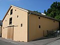
This is the category of the Bavarian Baudenkmal (cultural heritage monument) with the ID D-1-76-123-370 (Wikidata)
|
Deutsch: Antonistraße 41 Eichstätt: "Pfarrstiftszehentstadel", ehemaliger Zehentstadel, giebelständig mit Kalkplattendach, Bruchsteinmauerwerk im Obergeschoss durch innen liegendes Fachwerk verstärkt, erste Hälfte 18. Jahrhundert.
Media in category "Antonistraße 41 (Eichstätt)"
The following 2 files are in this category, out of 2 total.
-
 Antonistr 41 Eichstätt D-1-76-123-370.jpg 2,048 × 1,536; 904 KB
-
 Antonistr 41 Eichstätt.jpg 1,536 × 2,048; 896 KB
