Category:Ancien prieuré de Miserez (Miserez 127, Charmoille)
Jump to navigation
Jump to search
| Object location | | View all coordinates using: OpenStreetMap |
|---|
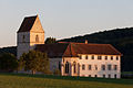
church building complex in Charmoille in the canton of Jura, Switzerland  | |||||
| Upload media | |||||
| Instance of | |||||
|---|---|---|---|---|---|
| Part of | |||||
| Location | Charmoille, La Baroche, Porrentruy District, Jura, Switzerland | ||||
| Street address |
| ||||
| Heritage designation | |||||
 | |||||
Media in category "Ancien prieuré de Miserez (Miserez 127, Charmoille)"
This category contains only the following file.
-
 B-Charmoille-Miserez-Prioriat.jpg 1,500 × 1,000; 1.38 MB