Category:Ancien manoir de Flaxlanden
Jump to navigation
Jump to search
| Object location | | View all coordinates using: OpenStreetMap |
|---|
|
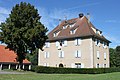
This building is inscrit au titre des monuments historiques de la France. It is indexed in the base Mérimée, a database of architectural heritage maintained by the French Ministry of Culture, under the references PA00085411
|
 | |||||
| Upload media | |||||
| Instance of | |||||
|---|---|---|---|---|---|
| Location | Durmenach, canton of Ferrette | ||||
| Street address |
| ||||
| Heritage designation |
| ||||
 | |||||
Media in category "Ancien manoir de Flaxlanden"
The following 3 files are in this category, out of 3 total.
-
 Ancien manoir de Flaxlanden (2).jpg 4,752 × 3,168; 5.28 MB
-
 Ancien manoir de Flaxlanden (3).jpg 4,752 × 3,168; 5.64 MB
-
 Ancien manoir de Flaxlanden.jpg 4,752 × 3,168; 4.8 MB
.jpg)
.jpg)
Categories:
- Durmenach
- Monuments historiques in Haut-Rhin (castles)
- Castles in Arrondissement Altkirch
- Renaissance castles in Haut-Rhin
- Baroque castles in Haut-Rhin
- 16th-century castles in Haut-Rhin
- 17th-century castles in Haut-Rhin
- Built in Haut-Rhin in 1624
- Castles built in 1624
- Built in Haut-Rhin in 1694
- Castles built in 1694
- Flachslanden family