Category:Ancien manège, La Chaux-de-Fonds
Jump to navigation
Jump to search
| Object location | | View all coordinates using: OpenStreetMap |
|---|
 | |||||
| Upload media | |||||
| Instance of | |||||
|---|---|---|---|---|---|
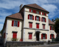
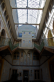
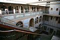
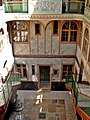
| Location | La Chaux-de-Fonds, Neuchâtel, Switzerland | ||||
| Street address |
| ||||
| Heritage designation | |||||
| Start time |
| ||||
 | |||||
Media in category "Ancien manège, La Chaux-de-Fonds"
The following 12 files are in this category, out of 12 total.
-
 0manege.png 1,280 × 1,020; 2.29 MB
-
 0manege2.png 848 × 1,280; 1.89 MB
-
 CF01.jpg 2,048 × 1,365; 1.01 MB
-
 Chaux de Fond manege PICT2239.jpg 1,704 × 2,272; 2.42 MB
-
 Innenhof L'Ancien Manège in La Chaux-de-Fonds.jpg 2,667 × 4,000; 6.4 MB
-
 Inside L'Ancien Manège in La Chaux-de-Fonds.jpg 2,667 × 4,000; 7.6 MB
-
 L'Ancien Manège La Chaux-de-Fonds.jpg 4,200 × 2,625; 6.42 MB
-
 LaChauxDeFondsAncienManègeCh1.jpg 4,288 × 2,848; 9.67 MB
-
 LaChauxDeFondsAncienManègeCh2.jpg 4,046 × 2,687; 7.24 MB
-
 Manege.png 3,862 × 3,077; 14.96 MB
-
 Manege2.png 3,264 × 4,928; 19.66 MB
-
 Manège Chaux-de-Fonds.JPG 1,704 × 2,272; 640 KB


