Category:Anarita
Jump to navigation
Jump to search
| Object location | | View all coordinates using: OpenStreetMap |
|---|
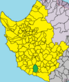
community in Paphos District, Republic of Cyprus  Anarita in Paphos District. | |||||
| Upload media | |||||
| Instance of | |||||
|---|---|---|---|---|---|
| Location | Paphos District, Cyprus | ||||
| Located in or next to body of water | |||||
| Executive body |
| ||||
| Head of government |
| ||||
| Population |
| ||||
| Area |
| ||||
| Elevation above sea level |
| ||||
| official website | |||||
 | |||||
Media in category "Anarita"
This category contains only the following file.
-
 PaphosDistrictAnarita.png 1,541 × 1,840; 132 KB