Category:Anamudi
Jump to navigation
Jump to search
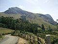
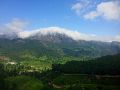
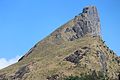
Anamudi (Malayalam: ആനമുടി) is the highest peak in the Western Ghats in India, having an elevation of 2,695 metres (8,842 ft). It is located in the southern region of Eravikulam National Park at the junction of the Cardamom Hills, the Anaimalai Hills and the Palni Hills. The nearest town is Munnar, 13 km away. Anamudi is a derived word from Malayalam meaning "Elephant Peak" and Anamudi, meaning elephant's brow as well as Elephant Head or Peak. Anamudi is the highest point in South India, and also the highest point in India outside the Himalayas. 10°10′0″N 77°04′0″E / 10.16667°N 77.06667°E
mountain  | |||||
| Upload media | |||||
| Instance of | |||||
|---|---|---|---|---|---|
| Location | |||||
| Mountain range | |||||
| Topographic prominence |
| ||||
| Topographic isolation |
| ||||
| Elevation above sea level |
| ||||
 | |||||
Subcategories
This category has the following 2 subcategories, out of 2 total.
R
- Raorchestes resplendens (4 F)
V
- Views from Anamudi mountain (5 F)
Media in category "Anamudi"
The following 27 files are in this category, out of 27 total.
-
 A peak view of munnar. near anamudi. kerala.jpg 2,592 × 1,456; 893 KB
-
 ANAIMUDI MASSIF.jpg 3,084 × 926; 1.15 MB
-
 Anaimudi munnar.jpg 5,152 × 3,864; 7.12 MB
-
 Anaimudi munnar1.jpg 5,152 × 3,864; 7.76 MB
-
 Anaimudi munnar3.jpg 5,152 × 3,864; 8.26 MB
-
 Anaimudi N.P.&Anamalais.jpg 4,595 × 2,619; 1.25 MB
-
 Anaimudi peak.jpg 4,160 × 3,120; 5.27 MB
-
 Anaimudi Peak.jpg 3,264 × 2,448; 3.42 MB
-
 Anaimudi.jpg 3,072 × 2,304; 1.07 MB
-
 AnaimudiPeak DSC 4834.jpg 2,048 × 1,367; 1.19 MB
-
 Anamudi from Munnar Gundumalai road.jpg 1,208 × 906; 268 KB
-
 Anamudi kerala.jpg 1,024 × 768; 588 KB
-
 Anamudi peak - Elephants head.jpg 4,272 × 2,848; 5.88 MB
-
 Anamudi peak, Munnar.jpg 960 × 720; 85 KB
-
 Anamudi Views, Munnar - panoramio.jpg 1,208 × 906; 259 KB
-
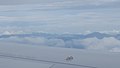 Anamudi-flight1.jpg 5,312 × 2,988; 852 KB
-
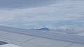 Anamudi-flight2.jpg 5,312 × 2,988; 1.12 MB
-
 Anamudi1.jpg 5,152 × 3,864; 8.02 MB
-
 Eravikulam National Park.jpg 2,892 × 2,304; 1.17 MB
-
 Hill station Kerala.jpg 5,184 × 3,456; 6 MB
-
 Kerala hill station.jpg 5,184 × 3,456; 6.31 MB
-
 Kerala peak.jpg 5,184 × 3,456; 8.56 MB
-
 Naikolli Mala near Anamudi.jpg 3,008 × 2,000; 2.29 MB
-
 Top of hill.jpg 1,920 × 2,560; 611 KB
-
 TREE FERN Western Ghats.jpg 4,608 × 3,456; 5.94 MB
-
 TREE FERNS AnaimudiN.P.jpg 4,554 × 2,777; 6.54 MB
-
 View of Anamudi from Rajamala, Munnar.jpg 2,048 × 1,536; 1.3 MB


