Category:Amerstraat (Lier)
Jump to navigation
Jump to search
English: Social housing project on the Amerstraat in Lier, next to the dike along the Nete. 42 flats over 4 buildings, on pillars because of the proximity of the river and the impossibility of excavating an underground car park.
Nederlands: Sociaal huisvestingsproject aan de Amerstraat te Lier, naast de dijk langs de Nete. 42 appartementen over 4 gebouwen, op pijlers vanwege nabije rivier en onmogelijkheid ondergrondse parkeergarage uit te graven.
| Object location | | View all coordinates using: OpenStreetMap |
|---|
Media in category "Amerstraat (Lier)"
The following 6 files are in this category, out of 6 total.
-
 Amerstraat 01.jpg 6,000 × 4,000; 7.37 MB
-
 Amerstraat 02.jpg 6,000 × 4,000; 7.23 MB
-
 Amerstraat 03.jpg 6,000 × 4,000; 6.86 MB
-
 Amerstraat 04.jpg 6,000 × 4,000; 7.15 MB
-
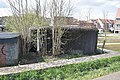 Bunker Amerstraat 1.jpg 6,000 × 4,000; 6.67 MB
-
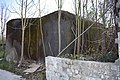 Bunker Amerstraat 2.jpg 6,000 × 4,000; 5.37 MB


