Category:Amedzofe
Jump to navigation
Jump to search
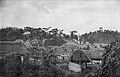
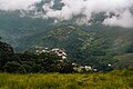
Amedzofe (hist. Amedschowe) is a small village in the Ho West District of the Volta Region of Ghana. The area around this village belongs to the traditional Avatime area (Ewe people). The core area of Amedzofe is located around of
| Object location | | View all coordinates using: OpenStreetMap |
|---|
human settlement  | |||||
| Upload media | |||||
| Instance of | |||||
|---|---|---|---|---|---|
| Location | Hohoe Municipal District, Volta Region, Ghana | ||||
 | |||||
Media in category "Amedzofe"
The following 46 files are in this category, out of 46 total.
-
 A view of amedzope town from mounitain gemi.jpg 3,238 × 2,000; 4.81 MB
-
 A view of communities and landscapes from mounitain gemi in amedzope (1).jpg 3,911 × 2,200; 3.96 MB
-
 A view of communities and landscapes from mounitain gemi in amedzope (2).jpg 3,911 × 2,200; 3.98 MB
-
 A view of communities and landscapes from mounitain gemi in amedzope (3).jpg 3,911 × 2,200; 4.33 MB
-
 Amedzofe & Mt Gemi.jpg 5,636 × 3,018; 18.33 MB
-
 Amedzofe BlickVomGemi 1892 300dpi.jpg 2,737 × 1,880; 851 KB
-
 Amedzofe Dorf 1892 300dpi.jpg 2,962 × 1,895; 1.72 MB
-
 Amedzofe Dorfplatz 1892 300dpi.jpg 2,922 × 1,905; 1.88 MB
-
 Amedzofe Missionsstation 1892 300dpi.jpg 2,965 × 1,914; 2.01 MB
-
 Amedzofe Town Facing the mountain Gemi.jpg 3,936 × 2,624; 700 KB
-
 Amedzofe Township.JPG 2,048 × 1,536; 1.23 MB
-
 Amedzofe village Ghana.jpg 6,000 × 4,000; 24.34 MB
-
 Amedzofe Volta region Ghana.jpg 4,000 × 6,000; 27.19 MB
-
 Amedzofe WegZurMissionsstation 1892 300dpi.jpg 2,976 × 1,895; 2.5 MB
-
 Amedzope mountain. fog formation in sequence (1).jpg 3,611 × 2,200; 5.4 MB
-
 Amedzope mountain. fog formation in sequence (2).jpg 3,559 × 2,200; 4.85 MB
-
 Amedzope mountain. fog formation in sequence (3).jpg 3,454 × 2,200; 4.68 MB
-
 Amedzope mountain. fog formation in sequence (4).jpg 3,584 × 2,200; 5.15 MB
-
 Building 90.jpg 3,888 × 2,592; 2.95 MB
-
 Building Amedzofe.jpg 3,936 × 2,624; 687 KB
-
 Captivating view of Ote waterfall.jpg 4,000 × 6,000; 17.37 MB
-
 Clay Building in Amedzofe.jpg 3,936 × 2,624; 792 KB
-
 Dense clouds at over the Ote Waterfalls at Amedzope.jpg 3,024 × 4,032; 1.76 MB
-
 E.P College Of Education, Amedzofe Administrative block.jpg 3,936 × 2,624; 750 KB
-
 E.P College Of Education, Amedzofe Entrance.jpg 3,936 × 2,624; 722 KB
-
 E.P College Of Education, Amedzofe Old administrative block.jpg 3,936 × 2,624; 763 KB
-
 EP Collage of Education Entrance 2.jpg 3,936 × 2,624; 698 KB
-
 EP college of education Amedzofe.jpg 3,936 × 2,624; 4.03 MB
-
 Fascinating view of Ote waterfall.jpg 4,000 × 6,000; 18.9 MB
-
 Gated House Amedzofe.jpg 3,936 × 2,624; 775 KB
-
 Moderate Home.jpg 3,936 × 2,624; 679 KB
-
 Ote otay Falls.jpg 2,624 × 3,936; 725 KB
-
 Ote waterfall (1).jpg 4,000 × 6,000; 15.24 MB
-
 Ote waterfall jpeg.jpg 4,000 × 6,000; 15.56 MB
-
 Ote waterfall jpg.jpg 6,000 × 4,000; 20.51 MB
-
 Ote Waterfall.jpg 3,605 × 2,200; 3.21 MB
-
 Path way Amedzofe.jpg 2,624 × 3,936; 608 KB
-
 Rev. W.M. Beveridge, M.Ed.jpg 2,624 × 3,936; 5 MB
-
 Rocky Ote waterfall jpeg.jpg 6,000 × 4,000; 19.51 MB
-
 Rocky Ote waterfall.jpg 6,000 × 4,000; 20.49 MB
-
 Rocky view of Ote waterfall.jpg 4,000 × 6,000; 24.84 MB
-
 Waterfall at Ote Falls, Amedzope.jpg 3,024 × 4,032; 5.55 MB
-
 Waterfalls of Ote Ghana.jpg 4,000 × 6,000; 23.37 MB
-
 Wikilovesafrica9760.jpg 3,936 × 2,624; 859 KB
-
 Wikilovesafrica9762.jpg 3,936 × 2,624; 872 KB
-
 Wikilovesafrica9810.jpg 6,016 × 4,016; 915 KB

.jpg)
.jpg)
.jpg)


.jpg)
.jpg)
.jpg)
.jpg)


.jpg)


