Category:Ambachtstraat 12, Utrecht
Jump to navigation
Jump to search
| Object location | | View all coordinates using: OpenStreetMap |
|---|
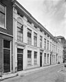
building in Utrecht, Netherlands  | |||||
| Upload media | |||||
| Instance of | |||||
|---|---|---|---|---|---|
| Location | Utrecht, Netherlands | ||||
| Heritage designation |
| ||||
 | |||||
|
This is a category about rijksmonument number 36011
|
| Address |
|
Media in category "Ambachtstraat 12, Utrecht"
The following 4 files are in this category, out of 4 total.
-
 Ambachtstraat 12 - Utrecht.JPG 2,848 × 4,288; 4.78 MB
-
 Exterieur VOORGEVEL - Utrecht - 20314751 - RCE.jpg 788 × 1,200; 181 KB
-
 Exterieur VOORGEVEL - Utrecht - 20314752 - RCE.jpg 788 × 1,200; 200 KB
-
 Exterieur VOORGEVELS - Utrecht - 20314748 - RCE.jpg 960 × 1,200; 230 KB


