Category:Amargosa Range
Jump to navigation
Jump to search
mountain range in California and Nevada  | |||||
| Upload media | |||||
| Instance of | |||||
|---|---|---|---|---|---|
| Located in protected area | |||||
| Location |
| ||||
| Has part(s) | |||||
| Length |
| ||||
| Mountain range | |||||
| Highest point |
| ||||
| Elevation above sea level |
| ||||
 | |||||
Subcategories
This category has the following 2 subcategories, out of 2 total.
A
- Artists Palette (17 F)
Z
- Zabriskie Point (223 F)
Media in category "Amargosa Range"
The following 32 files are in this category, out of 32 total.
-
-
 Amargosa Range from California State Route 190.jpg 2,592 × 1,944; 2.41 MB
-
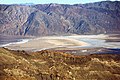
 Amargosa Range, Death Valley National Park, California (15516615089).jpg 4,000 × 3,000; 2.52 MB
-
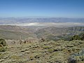
 Amargosa Range, Death Valley National Park, California (15516644879).jpg 4,000 × 3,000; 3.47 MB
-
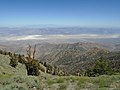
 Amargosa Range, Death Valley National Park, California (15517095488).jpg 4,000 × 1,990; 1.55 MB
-
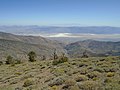
 Amargosa Range, Death Valley National Park, California (15517096268).jpg 4,000 × 3,000; 2.91 MB
-
 Amargosa Range, Death Valley National Park, California (15700609261).jpg 4,000 × 3,000; 2.94 MB
-
 Badwater Basin (-86 m), Death Valley and Amargosa Range.jpg 2,592 × 1,944; 2.38 MB
-
 Badwater Basin, Death Valley and Amargosa Range from Telescope Peak Summit.jpg 2,592 × 1,944; 2.38 MB
-
 Badwater Basin, Death Valley and Amargosa Range from Telescope Peak Trail.jpg 2,592 × 1,944; 2.4 MB
-
 Badwater Basin, Death Valley and Amargosa Range from Telescope Peak.jpg 2,592 × 1,944; 2.41 MB
-
 Badwater Basin, Death Valley and Amargosa Range.jpg 2,592 × 1,944; 2.41 MB
-
 Dante's View (1 669 m) to Death Valley, Amargosa Range.jpg 2,592 × 1,944; 2.35 MB
-
 Dante's View to Death Valley, Amargosa Range.jpg 2,592 × 1,944; 2.4 MB
-
 Death Valley and Amargosa Range from Telescope Peak 2019.jpg 2,592 × 1,944; 2.41 MB
-
 Death Valley and Amargosa Range from Telescope Peak.jpg 2,592 × 1,944; 2.4 MB
-
 Death Valley with Badwater Basin and Amargosa Range.jpg 2,592 × 1,944; 2.4 MB
-
 Death Valley, Badwater Basin (-86 m) and Amargosa Range from Telescope Peak.jpg 2,592 × 1,944; 2.41 MB
-
 Death Valley, Badwater Basin and Amargosa Range from Telescope Peak.jpg 2,592 × 1,944; 2.36 MB
-
 Panamint Range and Amargosa Range from Stovepipe Wells.jpg 2,592 × 1,944; 2.28 MB
-
 Panamint Range slopes, Death Valley and Amargosa Range.jpg 2,592 × 1,944; 2.4 MB
-
 Relief map of USA Nevada Amargosa Range.png 882 × 1,297; 1.35 MB
-
 Valle de la Muerte 1989 07.jpg 1,054 × 704; 188 KB
-
 Valle de la Muerte 1989 08.jpg 1,054 × 704; 394 KB
-
 Valle de la Muerte 1989 09.jpg 1,042 × 622; 336 KB
-
 Valle de la Muerte 1989 10.jpg 1,009 × 670; 319 KB
-
 Valle de la Muerte 1989 11.jpg 1,054 × 695; 189 KB
-
 Valle de la Muerte 1989 12.jpg 695 × 1,044; 187 KB
-
 Valle de la Muerte 1989 13.jpg 1,036 × 672; 241 KB
-
 Valle de la Muerte 1989 14.jpg 995 × 647; 323 KB
-
 Valle de la Muerte 1989 15.jpg 1,051 × 698; 207 KB
-
 Zabriskie Point, Amargosa Range.jpg 2,592 × 1,944; 2.39 MB

.jpg)
.jpg)
.jpg)
.jpg)
.jpg)
,_Death_Valley_and_Amargosa_Range.jpg)


_to_Death_Valley,_Amargosa_Range.jpg)


_and_Amargosa_Range_from_Telescope_Peak.jpg)


