Category:Altes Schulhaus (Gemeindehaus) (Dorfplatz 2, Sattel)
Jump to navigation
Jump to search
| Object location | | View all coordinates using: OpenStreetMap |
|---|
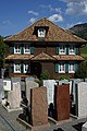
school building in Sattel in the canton of Schwyz, Switzerland  | |||||
| Upload media | |||||
| Instance of | |||||
|---|---|---|---|---|---|
| Part of | |||||
| Location | Sattel, Schwyz District, Schwyz, Switzerland | ||||
| Street address |
| ||||
| Heritage designation | |||||
 | |||||
Media in category "Altes Schulhaus (Gemeindehaus) (Dorfplatz 2, Sattel)"
This category contains only the following file.
-
 Picswiss SZ-20-21.jpg 300 × 450; 49 KB