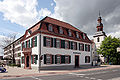
Category:Altes Rathaus Lampertheim
Jump to navigation
Jump to search
| Object location | | View all coordinates using: OpenStreetMap |
|---|
 | |||||
| Upload media | |||||
| Instance of | |||||
|---|---|---|---|---|---|
| Location | Lampertheim, Landkreis Bergstraße, Darmstadt Government Region, Hesse, Germany | ||||
| Street address |
| ||||
| Heritage designation | |||||
 | |||||
This is the category of the Hessian Kulturdenkmal (cultural monument) with the ID 136309 (Wikidata)
|
Media in category "Altes Rathaus Lampertheim"
The following 8 files are in this category, out of 8 total.
-
 Altes Rathaus Lampertheim.jpg 1,024 × 820; 121 KB
-
 Lampertheim 1.jpg 1,024 × 768; 145 KB
-
 Lampertheim Rathaus 01.jpg 3,504 × 2,336; 1.05 MB
-
 Lampertheim-03.jpg 2,048 × 1,536; 1.53 MB
-
 Lampertheim-06.jpg 2,048 × 1,536; 1.46 MB
-
 Lampertheim-08.jpg 2,048 × 1,536; 1.49 MB
-
 Lampertheim-09.jpg 2,048 × 1,536; 1.53 MB
-
 Lampertheim-15.jpg 2,048 × 1,536; 1.42 MB


