Category:Altes Rathaus (Hennigsdorf)
Jump to navigation
Jump to search
| Object location | | View all coordinates using: OpenStreetMap |
|---|
building in Hennigsdorf, Brandenburg state, Germany  | |||||
| Upload media | |||||
| Instance of | |||||
|---|---|---|---|---|---|
| Location | Hennigsdorf, Oberhavel District, Brandenburg, Germany | ||||
| Street address |
| ||||
| Heritage designation | |||||
 | |||||
This is the category of the Brandenburger Baudenkmal (cultural heritage monument) with the ID 09165046 (Wikidata)
|
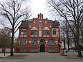
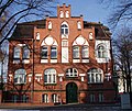
English: Pictures of the former town hall in Hennigsdorf, Hennigsdorf municipality, Oberhavel district, Brandenburg state, Germany.
Deutsch: Ansichten des Alten Rathauses in Hennigsdorf, Stadt Hennigsdorf, Landkreis Oberhavel, Land Brandenburg, Deutschland.
Français : Photos de l'ancienne mairie à Hennigsdorf, ville de Hennigsdorf, arrondissement de Oberhavel, état fédéral de Brandebourg, Allemagne
Español: Vistas de la antigua alcaldía en Hennigsdorf, ciudad de Hennigsdorf, distrito de Oberhavel, estado federado de Brandeburgo, Alemania
Adress
Hauptstraße 3, 16761 Hennigsdorf
Subcategories
This category has the following 2 subcategories, out of 2 total.
B
- Bürgerhaus Hennigsdorf (5 F)
G
Media in category "Altes Rathaus (Hennigsdorf)"
The following 7 files are in this category, out of 7 total.
-
 Altes Rathaus - registry office Hennigsdorf close up.jpg 3,286 × 2,759; 5.3 MB
-
 Altes Rathaus - registry office Hennigsdorf.jpg 3,237 × 2,730; 8.93 MB
-
 Altes Rathaus Hennigsdorf 2019 ESE.jpg 4,782 × 3,538; 7.99 MB
-
 Hauptstraße 3, Altes Rathaus.jpg 3,312 × 3,435; 12.14 MB
-
 Hennigsdorf - Altes Rathaus (Old Town Hall) - geo.hlipp.de - 41554.jpg 480 × 640; 106 KB
-
 Hennigsdorf Duerks plaque.jpg 2,070 × 1,950; 472 KB
-
 Rathaus Hdf.jpg 1,698 × 1,431; 317 KB


_-_geo.hlipp.de_-_41554.jpg)

