Category:Alter Friedhof Weener
Jump to navigation
Jump to search
| Object location | | View all coordinates using: OpenStreetMap |
|---|
Media in category "Alter Friedhof Weener"
The following 23 files are in this category, out of 23 total.
-
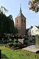 Weener - Burgstraße - Alter Friedhof + Glockenturm 01 ies.jpg 3,745 × 5,616; 18.78 MB
-
 Weener - Burgstraße - Alter Friedhof + Glockenturm 02 ies.jpg 3,745 × 5,616; 19.67 MB
-
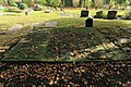
 Weener - Burgstraße - Alter Friedhof 01 ies.jpg 3,744 × 5,616; 24.65 MB
-
 Weener - Burgstraße - Alter Friedhof 02 ies.jpg 5,616 × 3,744; 29.97 MB
-
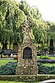
 Weener - Burgstraße - Alter Friedhof 03 ies.jpg 5,616 × 3,744; 26.57 MB
-
 Weener - Burgstraße - Alter Friedhof 04 ies.jpg 5,616 × 3,744; 23.27 MB
-
 Weener - Burgstraße - Alter Friedhof 05 ies.jpg 5,616 × 3,744; 21.92 MB
-
 Weener - Burgstraße - Alter Friedhof 06 ies.jpg 5,616 × 3,744; 22.56 MB
-
 Weener - Burgstraße - Alter Friedhof 07 ies.jpg 5,616 × 3,744; 20.35 MB
-
 Weener - Burgstraße - Alter Friedhof 08 ies.jpg 3,744 × 5,616; 23.71 MB
-
 Weener - Burgstraße - Alter Friedhof 09 ies.jpg 5,616 × 3,744; 24.6 MB
-
 Weener - Burgstraße - Alter Friedhof 10 ies.jpg 3,744 × 5,616; 18.32 MB
-
 Weener - Burgstraße - Alter Friedhof 11 ies.jpg 3,744 × 5,616; 20.23 MB
-
 Weener - Burgstraße - Alter Friedhof 12 ies.jpg 5,616 × 3,744; 23.05 MB
-
 Weener - Burgstraße - Alter Friedhof 13 ies.jpg 5,616 × 3,743; 26.59 MB
-
 Weener - Burgstraße - Alter Friedhof 14 ies.jpg 5,616 × 3,744; 23.52 MB
-
 Weener - Burgstraße - Alter Friedhof 15 ies.jpg 5,616 × 3,744; 24.77 MB
-
 Weener - Burgstraße - Alter Friedhof 16 ies.jpg 3,744 × 5,616; 18.94 MB
-
 Weener - Burgstraße - Alter Friedhof 17 ies.jpg 5,616 × 3,744; 24.09 MB
-
 Weener - Burgstraße - Alter Friedhof 18 ies.jpg 5,616 × 3,744; 20.86 MB
-
 Weener - Burgstraße - Alter Friedhof 19 ies.jpg 3,744 × 5,616; 21.38 MB
-
 Weener - Burgstraße - Alter Friedhof 20 ies.jpg 3,744 × 5,616; 18.78 MB
-
 Weener - Norderstraße - Alter Friedhof 01 ies.jpg 5,616 × 3,744; 20.46 MB


