Category:Alstonefield
Jump to navigation
Jump to search
village in Staffordshire, England, UK  | |||||
| Upload media | |||||
| Instance of | |||||
|---|---|---|---|---|---|
| Location | Staffordshire Moorlands, Staffordshire, West Midlands, England | ||||
| Population |
| ||||
| Said to be the same as | Alstonefield (Wikimedia duplicated page, civil parish) | ||||
 | |||||
Subcategories
This category has the following 6 subcategories, out of 6 total.
Media in category "Alstonefield"
The following 200 files are in this category, out of 376 total.
(previous page) (next page)-
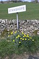 A cheerful welcome to Stanshope - geograph.org.uk - 560666.jpg 427 × 640; 95 KB
-
 A Dipper by the Dove - geograph.org.uk - 5686925.jpg 2,000 × 1,500; 2.14 MB
-
 A fine sunny day in Hall Dale near Stanshope - geograph.org.uk - 4668831.jpg 1,024 × 768; 196 KB
-
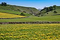
 A good year for dandelions - geograph.org.uk - 1858746.jpg 800 × 600; 159 KB
-
 A herd of Belted Galloways, Alstonefield - geograph.org.uk - 5537120.jpg 1,600 × 1,200; 777 KB
-
 A moss covered stone wall on Millway Lane at Milldale - geograph.org.uk - 6285613.jpg 4,545 × 3,636; 4.84 MB
-
 A narrow field on the top of a slope, above Milldale - geograph.org.uk - 5537024.jpg 1,600 × 1,200; 757 KB
-
 A pointless stile - geograph.org.uk - 2426715.jpg 640 × 480; 86 KB
-
 A view from Smithyfields Campsite in Alstonefield - geograph.org.uk - 6286109.jpg 5,472 × 3,648; 5.6 MB
-
 A view of Under Wetton - geograph.org.uk - 3186827.jpg 4,000 × 3,000; 2.44 MB
-

-
 A warm summers morning in Beresford Dale - geograph.org.uk - 6428605.jpg 1,797 × 1,198; 490 KB
-
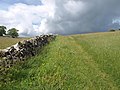
 A White Peak wall - geograph.org.uk - 2311824.jpg 427 × 640; 116 KB
-
 Above NT Gypsy Bank - geograph.org.uk - 5080649.jpg 3,456 × 2,304; 4.98 MB
-
 Alstonefield - geograph.org.uk - 2308560.jpg 640 × 427; 282 KB
-
 Alstonefield - geograph.org.uk - 4722724.jpg 4,375 × 2,596; 1.78 MB
-
 Alstonefield - village green - geograph.org.uk - 5621923.jpg 5,184 × 2,920; 6.97 MB
-
 Alstonefield Geo-Hut - geograph.org.uk - 1759279.jpg 2,048 × 1,536; 627 KB
-
 Alstonefield Geo-Hut - geograph.org.uk - 3186815.jpg 4,000 × 3,000; 2.44 MB
-
 Alstonefield memorial hall and community centre - geograph.org.uk - 5537089.jpg 1,600 × 1,200; 786 KB
-
 Alstonefield village. - geograph.org.uk - 4884111.jpg 640 × 480; 63 KB
-
 Alstonefield Youth Hostel - geograph.org.uk - 3430078.jpg 427 × 640; 266 KB
-
 Alstonefield Youth Hostel - geograph.org.uk - 7265.jpg 640 × 480; 134 KB
-
 Alstonefield Youth Hostel at Overdale - geograph.org.uk - 3112992.jpg 4,345 × 2,897; 2.62 MB
-
 Alstonefield, Derbyshire ... the old post office. (7032967585).jpg 4,340 × 3,260; 2.18 MB
-
 Alstonefield, from Ashbourne Lane - geograph.org.uk - 2865576.jpg 4,000 × 3,000; 2.37 MB
-
 Alstonefield, How Narrowdale, view looking north.jpg 3,500 × 2,332; 1.73 MB
-
 Alstonefield, view towards Narrowdale Hill.jpg 3,500 × 2,333; 1.72 MB
-
 Alstonfield Village - geograph.org.uk - 5358528.jpg 2,000 × 1,333; 2.12 MB
-
 Ann Green's grave marker - geograph.org.uk - 6242087.jpg 2,000 × 1,333; 3.63 MB
-

-
 Archford Moor - geograph.org.uk - 1956805.jpg 640 × 480; 85 KB
-
 At the junction of the paths - geograph.org.uk - 5082756.jpg 3,456 × 2,304; 4.63 MB
-
 Barn and Belted Galloway cattle - geograph.org.uk - 3023211.jpg 2,272 × 1,704; 1.88 MB
-
 Barn and cattle, Narrowdale - geograph.org.uk - 1956751.jpg 640 × 480; 97 KB
-
 Barn and fields near Pea Low - geograph.org.uk - 1956724.jpg 640 × 480; 85 KB
-
 Barn and lane - geograph.org.uk - 1870989.jpg 640 × 480; 75 KB
-
 Barn and view from above Hopedale - geograph.org.uk - 953491.jpg 640 × 480; 92 KB
-
 Barn by Lode Lane, Alstonefield - geograph.org.uk - 5041830.jpg 5,032 × 3,715; 4.32 MB
-
 Barn conversion, Alstonefield - geograph.org.uk - 3186793.jpg 4,000 × 3,000; 2.53 MB
-
 Barn off Beresford Lane - geograph.org.uk - 2308446.jpg 640 × 427; 239 KB
-
 Barns near Alstonefield - geograph.org.uk - 1759265.jpg 1,583 × 1,006; 394 KB
-
 Beresford Dale - geograph.org.uk - 5537220.jpg 1,200 × 1,600; 807 KB
-
 Beresford Lane at crossroads by Harecops farm - geograph.org.uk - 4184820.jpg 4,000 × 2,248; 4.19 MB
-
 Bottom of Harry's Bank - geograph.org.uk - 5705308.jpg 640 × 427; 135 KB
-
 Bridge across the River Dove - geograph.org.uk - 4786180.jpg 800 × 578; 211 KB
-
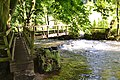
 Bridge and stepping stones upstream from Gipsy Bank - geograph.org.uk - 5537129.jpg 1,200 × 1,600; 749 KB
-
 Bridge over Dove upstream of Gipsy Bank - geograph.org.uk - 5537130.jpg 1,600 × 1,200; 808 KB
-
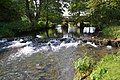
 Bridge over River Dove at Milldale - geograph.org.uk - 5537011.jpg 1,600 × 1,200; 823 KB
-
 Bridge over the River Dove at Milldale - geograph.org.uk - 5603322.jpg 883 × 592; 141 KB
-
 Bridge over the River Dove at Milldale. - geograph.org.uk - 6113159.jpg 1,024 × 544; 211 KB
-
 Bridge over The River Manifold at Westside Mill - geograph.org.uk - 4943637.jpg 5,184 × 3,888; 6.99 MB
-
 Bridge, not stepping stones - geograph.org.uk - 3023219.jpg 2,272 × 1,704; 3.17 MB
-
 Camping Barn over the field - geograph.org.uk - 5084273.jpg 3,456 × 2,304; 3.28 MB
-

-
 Cattle by Pasture Lane - geograph.org.uk - 2479850.jpg 640 × 471; 103 KB
-
 Cattle in Narrowdale - geograph.org.uk - 3676067.jpg 3,872 × 2,592; 4.17 MB
-
 Cattle resting in How Narrowdale - geograph.org.uk - 3112712.jpg 3,070 × 4,298; 2.72 MB
-
 Chapel Farmhouse, Alstonefield.jpg 3,296 × 2,472; 1.08 MB
-
 Church Street, Alstonefield - geograph.org.uk - 2835585.jpg 426 × 640; 111 KB
-
 Coldeaton Bridge - geograph.org.uk - 3680891.jpg 3,872 × 2,592; 4.62 MB
-
 Collapsed Shed - geograph.org.uk - 1745013.jpg 3,072 × 2,304; 3.2 MB
-
 Collapsed Wall, Beresford lane - geograph.org.uk - 2308555.jpg 640 × 427; 295 KB
-
 Cottage at Dale Bottom - geograph.org.uk - 1870991.jpg 640 × 480; 76 KB
-
 Cottage at Dale Bottom - geograph.org.uk - 2369344.jpg 768 × 1,024; 273 KB
-
 Cottage at Dale Bottom, Milldale - geograph.org.uk - 3413329.jpg 1,066 × 1,600; 541 KB
-
 Cottage at Dale Bottom, south of Alstonefield - geograph.org.uk - 3285991.jpg 1,024 × 768; 287 KB
-
 Cottage at Hope Bottom, Hopedale - geograph.org.uk - 2932829.jpg 4,000 × 2,672; 3.14 MB
-
 Cottage by the River Dove - geograph.org.uk - 695746.jpg 640 × 480; 113 KB
-
 Cottages at The Rakes, Alstonefield - geograph.org.uk - 3112919.jpg 4,608 × 3,072; 3.41 MB
-
 Cottages overlooking the River Dove - geograph.org.uk - 2502513.jpg 1,024 × 768; 304 KB
-

-
 Cows and calves on Narrowdale Hill - geograph.org.uk - 1956797.jpg 640 × 467; 99 KB
-
 Cows in the shade - geograph.org.uk - 4797263.jpg 6,000 × 4,000; 6.68 MB
-
 Crumbling facade, Narrowdale - geograph.org.uk - 2784111.jpg 1,024 × 768; 334 KB
-
 Daffodils on Church Street, Alstonefield - geograph.org.uk - 4426410.jpg 479 × 640; 139 KB
-
 Dale Bottom - geograph.org.uk - 5008269.jpg 5,184 × 2,931; 1.78 MB
-
 Damaged wall, Wolfscote Dale - geograph.org.uk - 5537151.jpg 1,600 × 1,200; 764 KB
-
 Damgate - geograph.org.uk - 198576.jpg 640 × 480; 79 KB
-
 Derelict farm, equipment and tractors - geograph.org.uk - 1956781.jpg 640 × 480; 117 KB
-
 Descending NT Gypsy Bank - geograph.org.uk - 5080661.jpg 3,456 × 2,304; 4.62 MB
-
 Dew pond and a view to Alstonefield - geograph.org.uk - 1956865.jpg 640 × 480; 71 KB
-
 Dewpond above Milldale - geograph.org.uk - 2480424.jpg 640 × 480; 109 KB
-
 Dove Dale ^ Hall Dale from path along its eastern rim - geograph.org.uk - 5621932.jpg 5,184 × 2,920; 6.57 MB
-
 Dove meanders south of Hartington - geograph.org.uk - 3520183.jpg 1,200 × 900; 1.48 MB
-
 Dovedale by the Dove Holes - geograph.org.uk - 4561018.jpg 6,000 × 4,000; 5.27 MB
-
 Dovedale, aerial 2015 - geograph.org.uk - 4687615.jpg 640 × 403; 55 KB
-
 Down to Coldeaton Bridge and River Dove - geograph.org.uk - 5080656.jpg 3,456 × 2,304; 4.52 MB
-
 Downhill towards the River Dove - geograph.org.uk - 2835612.jpg 640 × 426; 98 KB
-
 Drabber Tor - geograph.org.uk - 5080691.jpg 3,456 × 2,304; 4.97 MB
-
 Dry stone wall at Dovedale - geograph.org.uk - 4782936.jpg 800 × 738; 339 KB
-
 Dry stone wall overlooking Dovedale - geograph.org.uk - 4782298.jpg 800 × 600; 146 KB
-
 Dry stone wall, top of Harry's Bank - geograph.org.uk - 5705310.jpg 640 × 427; 164 KB
-
 Falling tree above a fish weir in the River Dove - geograph.org.uk - 4919655.jpg 2,048 × 3,648; 2.77 MB
-
 Farm Shop sign - geograph.org.uk - 1052965.jpg 640 × 480; 146 KB
-
 Fields below Narrowdale Hill - geograph.org.uk - 3676058.jpg 3,872 × 2,592; 4.49 MB
-
 Fields near Alstonefield - geograph.org.uk - 3678622.jpg 3,872 × 2,592; 4.22 MB
-
 Fields near Brook Lodge - geograph.org.uk - 4797260.jpg 6,000 × 4,000; 5.48 MB
-
 Fields near Field House Farm - geograph.org.uk - 2308528.jpg 640 × 427; 209 KB
-
 Fields of dandelions, Hall Dale (26732569630).jpg 9,543 × 4,312; 38.6 MB
-
 Fields of dandelions, Hall Dale (26938197961).jpg 7,427 × 4,951; 33.24 MB
-
 Fields of dandelions, Hall Dale (26973113136).jpg 8,077 × 5,385; 36.9 MB
-
 Fields to the west of Alstonefield - geograph.org.uk - 5537103.jpg 1,600 × 1,200; 923 KB
-
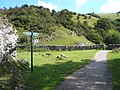
 Finger post at the foot of Hall Dale - geograph.org.uk - 2312666.jpg 640 × 427; 116 KB
-
 Finger post near Stanshope - geograph.org.uk - 2311795.jpg 640 × 427; 89 KB
-
 Fishing the Dove - geograph.org.uk - 4065899.jpg 1,920 × 1,432; 813 KB
-
 Footbridge and weir, Beresford Dale - geograph.org.uk - 5537179.jpg 1,600 × 1,200; 823 KB
-
 Footbridge below Frank's Rock - geograph.org.uk - 2834282.jpg 1,024 × 768; 318 KB
-

-
 Footbridge in Beresford Dale - geograph.org.uk - 2834275.jpg 1,024 × 768; 335 KB
-
 Footbridge in Beresford Dale - geograph.org.uk - 5537180.jpg 1,600 × 1,200; 857 KB
-
 Footbridge over River Dove - geograph.org.uk - 5082753.jpg 3,456 × 2,304; 5.79 MB
-
 Footbridge over River Dove, Beresford Dale - geograph.org.uk - 6339097.jpg 5,184 × 2,920; 6.42 MB
-
 Footbridge over the River Dove in Beresford Dale - geograph.org.uk - 3112687.jpg 4,248 × 2,832; 2.61 MB
-
 Footbridge to Westside Mill - geograph.org.uk - 2834355.jpg 1,024 × 768; 376 KB
-
 Footbridge, Beresford Dale - geograph.org.uk - 2308551.jpg 640 × 427; 291 KB
-

-
 Footpath and track north of Alstonefield - geograph.org.uk - 5537112.jpg 1,600 × 1,200; 733 KB
-
 Footpath Junction - geograph.org.uk - 559652.jpg 640 × 480; 140 KB
-
 Footpath near Lower Hurst Farm - geograph.org.uk - 2479482.jpg 3,296 × 2,472; 1.02 MB
-
 Footpath on 'Harry's Bank' - geograph.org.uk - 2369342.jpg 768 × 1,024; 349 KB
-
 Footpath to Milldale - geograph.org.uk - 2538793.jpg 640 × 480; 93 KB
-
 Ford and Footbridge at Beresford - geograph.org.uk - 3049256.jpg 3,264 × 2,448; 4.46 MB
-
 Former Coach House, Alstonefield.jpg 640 × 427; 287 KB
-
 Former grocer's shop, Alstonefield - geograph.org.uk - 5537076.jpg 1,600 × 1,200; 782 KB
-
 Former Lode Mill near Alstonefield - geograph.org.uk - 6004814.jpg 5,184 × 2,920; 6.61 MB
-

-
 Frank i' th' Rocks Bridge across the River Dove - geograph.org.uk - 3113063.jpg 4,608 × 3,072; 3.36 MB
-
 Frank i' th' rocks footbridge - geograph.org.uk - 1841936.jpg 640 × 445; 73 KB
-
 Gate and squeeze stile, north of Alstonefield - geograph.org.uk - 5537116.jpg 1,600 × 1,200; 743 KB
-
 Gate into Fields near Narrowdale - geograph.org.uk - 2308544.jpg 640 × 427; 264 KB
-
 Gate on the Dovedale walk - geograph.org.uk - 3366451.jpg 640 × 427; 208 KB
-
 Gate, Narrowdale - geograph.org.uk - 3430064.jpg 640 × 427; 300 KB
-
 Gateham Farm - geograph.org.uk - 1956812.jpg 640 × 480; 84 KB
-
 Gateham Farm in 1984 - geograph.org.uk - 3221510.jpg 1,221 × 823; 154 KB
-
 Gateham Grange - geograph.org.uk - 4722725.jpg 5,184 × 3,456; 1.92 MB
-
 Gateham Grange - geograph.org.uk - 4722732.jpg 5,184 × 3,456; 2.03 MB
-
 Gateham, a field barn - geograph.org.uk - 3186830.jpg 4,000 × 3,000; 2.47 MB
-
 Gipsy Bank and view to the valley of The River Dove - geograph.org.uk - 3113005.jpg 4,298 × 3,070; 2.91 MB
-
 Gipsy bank. - geograph.org.uk - 4884121.jpg 640 × 384; 71 KB
-
 Going down to Milldale - geograph.org.uk - 1868121.jpg 640 × 480; 60 KB
-
 Green Farm, Alstonefield - geograph.org.uk - 3678818.jpg 3,872 × 2,592; 3.87 MB
-
 Green Farmhouse, Alstonefield.jpg 4,411 × 2,941; 2.73 MB
-
 Green fields on the edge of Alstonefield - geograph.org.uk - 3678823.jpg 3,872 × 2,592; 4.2 MB
-
 Green Well Alstonefield - geograph.org.uk - 1254475.jpg 640 × 480; 77 KB
-
 Green Well Alstonefield - geograph.org.uk - 1254488.jpg 640 × 480; 111 KB
-
 Green Well, Alstonefield - geograph.org.uk - 3186807.jpg 4,000 × 3,000; 2.65 MB
-
 Gypsy Bank - geograph.org.uk - 1231002.jpg 640 × 480; 148 KB
-
 Gypsy Lane - geograph.org.uk - 3430085.jpg 427 × 640; 253 KB
-
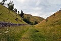
 Hall Dale - geograph.org.uk - 2391974.jpg 1,024 × 768; 253 KB
-
 Hall Dale - geograph.org.uk - 563475.jpg 427 × 640; 101 KB
-
 Hall Dale looking towards Stanshope - geograph.org.uk - 1879613.jpg 3,648 × 2,736; 2.32 MB
-
 Hall Dale, entrance.jpg 4,000 × 2,660; 2.72 MB
-
 Hall Dale, view.jpg 4,000 × 2,660; 2.56 MB
-
 Harecops - geograph.org.uk - 4722604.jpg 5,184 × 2,770; 1.92 MB
-
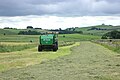 Haymaking near Overdale - geograph.org.uk - 5080624.jpg 3,456 × 2,304; 4.11 MB
-
 Heading down Hall Dale into Dovedale - geograph.org.uk - 3266660.jpg 1,600 × 1,066; 221 KB
-
 Hillside above Dovedale - geograph.org.uk - 4797272.jpg 6,000 × 4,000; 4.03 MB
-

-
 Hope Green Farm - geograph.org.uk - 5041823.jpg 5,184 × 3,888; 6.3 MB
-
 Hope Road - geograph.org.uk - 5008268.jpg 4,800 × 2,971; 1.86 MB
-
 Hopedale - geograph.org.uk - 4463554.jpg 1,280 × 851; 387 KB
-
 Hopedale - geograph.org.uk - 4464128.jpg 1,280 × 851; 363 KB
-

-
 How Narrowdale - geograph.org.uk - 1956732.jpg 800 × 600; 112 KB
-
 How Narrowdale - geograph.org.uk - 3360723.jpg 4,000 × 3,000; 4.04 MB
-
 Hurt's Wood - geograph.org.uk - 4462386.jpg 1,920 × 1,440; 1.14 MB
-
 In How Narrowdale - geograph.org.uk - 2834299.jpg 1,024 × 768; 144 KB
-
 Inside Milldale Chapel - geograph.org.uk - 6285616.jpg 5,205 × 3,470; 5.55 MB
-
 Is it a bird^ - geograph.org.uk - 2502523.jpg 768 × 1,024; 276 KB
-
 Junction of footpaths on the edge of Alstonefield - geograph.org.uk - 3678638.jpg 3,872 × 2,592; 4.13 MB
-
 Junction of paths east of Greenhills Cottage - geograph.org.uk - 3112729.jpg 2,946 × 4,419; 2.92 MB
-
 Junction of paths in Dovedale - geograph.org.uk - 3542163.jpg 3,648 × 2,736; 2.19 MB
-
 Junction of paths south of Narrowdale Hill - geograph.org.uk - 3112897.jpg 4,608 × 3,072; 3.46 MB
-
 Knoll Above Wolfscote Dale - geograph.org.uk - 2479349.jpg 3,296 × 2,472; 1.21 MB
-
 Land Rover, beyond redemption - geograph.org.uk - 1956771.jpg 640 × 480; 140 KB
-
 Lane and Footpath Junction near Gateham Grange - geograph.org.uk - 2479443.jpg 3,296 × 2,472; 1.05 MB
-
 Lane and River Dove near Milldale - geograph.org.uk - 4783181.jpg 800 × 600; 256 KB
-
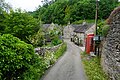
 Lane passing through Mill Dale - geograph.org.uk - 4786165.jpg 800 × 639; 210 KB
-
 Lane past Grove Farm, Stanshope - geograph.org.uk - 3418757.jpg 1,066 × 1,600; 595 KB
-
 Limestone barn below Narrowdale Hill - geograph.org.uk - 3112718.jpg 3,988 × 2,849; 2.43 MB
-
 Limestone barn north east of Alstonefield - geograph.org.uk - 3112997.jpg 4,290 × 2,860; 2.67 MB
-
 Limestone barn south of Beresford Lane - geograph.org.uk - 3112690.jpg 4,608 × 3,072; 3.43 MB
-
 Limestone Stile near Stanshope - geograph.org.uk - 563459.jpg 426 × 640; 130 KB
-
 Lode Mill - geograph.org.uk - 4722476.jpg 5,184 × 3,456; 1.69 MB
-
 Lode Mill by The River Dove - geograph.org.uk - 5041827.jpg 3,888 × 5,184; 6.1 MB
-
 Lode Plantation - geograph.org.uk - 4723399.jpg 5,184 × 3,456; 1.76 MB
-
 Looking across Gipsy Bank to the Dove valley - geograph.org.uk - 5537122.jpg 1,600 × 1,200; 892 KB
-
 Looking East from Back of Ecton - geograph.org.uk - 1453260.jpg 640 × 480; 65 KB
-

-
 Looking over Hope Marsh - geograph.org.uk - 2392008.jpg 1,024 × 768; 222 KB
-
 Looking over How Narrowdale - geograph.org.uk - 2834306.jpg 1,024 × 768; 189 KB
-
 Looking to Gipsy Bank and the Dove valley - geograph.org.uk - 5537125.jpg 1,600 × 1,200; 808 KB
-
 Looking Towards Harecops - geograph.org.uk - 2479474.jpg 3,296 × 2,472; 1,013 KB
-
 Low plantation. - geograph.org.uk - 4884101.jpg 640 × 480; 43 KB
-
 Manifold Valley, Milldale - geograph.org.uk - 5720611.jpg 640 × 427; 127 KB
-
 Meanders in the Dove - geograph.org.uk - 1841963.jpg 640 × 480; 61 KB
-
 Milepost, Alstonefield.jpg 492 × 701; 67 KB
-
 Milepost, Lode, Alstonefield.jpg 492 × 701; 66 KB
-
 Milldale - geograph.org.uk - 4556273.jpg 6,000 × 4,000; 5.7 MB


.jpg)


.jpg)
.jpg)
.jpg)


