Category:Alsdorfer Bergmannskreuz
Jump to navigation
Jump to search
| Camera location | | View all coordinates using: OpenStreetMap |
|---|
 | |||||
| Upload media | |||||
| Instance of | |||||
|---|---|---|---|---|---|
| Location | Simmerath, Aachen cities region, Cologne Government Region, North Rhine-Westphalia, Germany | ||||
 | |||||
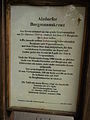
Inschrift Plakette: "Gedenket der 271 Opfer des Grubenunglücks vom 21.10.1930 in Alsdorf. Eifelverein Alsdorf, erneuert 1988"
Media in category "Alsdorfer Bergmannskreuz"
The following 8 files are in this category, out of 8 total.
-
 Alsdorfer Bergamnnskreuz (2).jpg 1,540 × 1,610; 1.31 MB
-
 Alsdorfer Bergmannkreuz, Belgenbacher Tal.JPG 1,312 × 1,918; 707 KB
-
 Alsdorfer Bergmannskreuz 1.JPG 4,608 × 3,456; 1.52 MB
-
 Alsdorfer Bergmannskreuz 2.JPG 3,456 × 4,608; 1.89 MB
-
 Alsdorfer Bergmannskreuz 3.JPG 4,608 × 3,456; 3 MB
-
 Alsdorfer Bergmannskreuz 4.JPG 3,456 × 4,608; 1.53 MB
-
 Alsdorfer Bergmannskreuz.JPG 3,456 × 4,608; 1.5 MB
-
 Alsdorfer Bermannkreuz, Belgenbacher Tal.JPG 1,886 × 2,672; 1.13 MB
.jpg)


