Category:Allée couverte du Champ-Grosset
Jump to navigation
Jump to search
|
This building is classé au titre des monuments historiques de la France. It is indexed in the base Mérimée, a database of architectural heritage maintained by the French Ministry of Culture, under the reference PA00089549
|
| Object location | | View all coordinates using: OpenStreetMap |
|---|
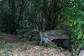
dolmen in Quessoy, France  | |||||
| Upload media | |||||
| Instance of | |||||
|---|---|---|---|---|---|
| Location | Quessoy, canton of Moncontour | ||||
| Heritage designation |
| ||||
 | |||||
Media in category "Allée couverte du Champ-Grosset"
The following 6 files are in this category, out of 6 total.
-
 Allée couverte (Hénon).jpg 4,000 × 3,000; 5.31 MB
-
 Dolmen du Champ-Grosset, Quessoy, France.jpg 4,115 × 2,743; 6.24 MB
-
 Quessoy alc champ-grosset 01.jpg 4,608 × 3,072; 2.7 MB
-
 Quessoy alc champ-grosset 02.jpg 3,977 × 4,593; 3.71 MB
-
 Quessoy alc champ-grosset 03.jpg 6,922 × 3,012; 4.11 MB
-
 Vue de l'allée couverte du Champ-Grosset.jpg 4,000 × 3,000; 5.15 MB
.jpg)


