Category:Allée couverte de Kernescop
Jump to navigation
Jump to search
| Object location | | View all coordinates using: OpenStreetMap |
|---|
|
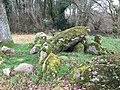
This building is classé au titre des monuments historiques de la France. It is indexed in the base Mérimée, a database of architectural heritage maintained by the French Ministry of Culture, under the reference PA00089313
|
 | |||||
| Upload media | |||||
| Instance of | |||||
|---|---|---|---|---|---|
| Location | Lohuec, Côtes-d'Armor, Brittany, Western defense and security zone, Metropolitan France, France | ||||
| Heritage designation |
| ||||
 | |||||
Media in category "Allée couverte de Kernescop"
The following 5 files are in this category, out of 5 total.
-
 Allée Couverte de Kernescop 1 - Lohuec.jpg 4,032 × 3,024; 4.11 MB
-
 Allée Couverte de Kernescop 2 - Lohuec.jpg 3,024 × 4,032; 4.93 MB
-
 Allée Couverte de Kernescop 3 - Lohuec.jpg 4,032 × 3,024; 4.82 MB
-
 Allée couverte de Kernescop à Lohuec 01.JPG 2,560 × 1,920; 3.25 MB
-
 Allée couverte de Kernescop à Lohuec 02.JPG 2,560 × 1,920; 3.28 MB


