Category:Allée couverte de Dampsmesnil
Jump to navigation
Jump to search
|
This building is classé au titre des monuments historiques de la France. It is indexed in the base Mérimée, a database of architectural heritage maintained by the French Ministry of Culture, under the reference PA00099385
|
| Object location | | View all coordinates using: OpenStreetMap |
|---|
gallery grave in Dampsmesnil, France  | |||||
| Upload media | |||||
| Instance of | |||||
|---|---|---|---|---|---|
| Location |
| ||||
| Street address |
| ||||
| Heritage designation |
| ||||
 | |||||
Media in category "Allée couverte de Dampsmesnil"
The following 26 files are in this category, out of 26 total.
-
 Allée couverte de Dampmesnil 2017-10 n01.jpg 4,928 × 3,280; 12.58 MB
-
 Allée couverte de Dampmesnil 2017-10 n02.jpg 3,280 × 4,373; 8.11 MB
-
 Allée couverte de Dampmesnil 2017-10 n03.jpg 4,928 × 3,280; 14.48 MB
-
 Allée couverte de Dampmesnil 2017-10 n04.jpg 4,928 × 3,280; 14.13 MB
-
 Allée couverte de Dampmesnil 2017-10 n05.jpg 4,928 × 3,280; 8.88 MB
-
 Allée couverte de Dampmesnil 2017-10 n06.jpg 4,928 × 3,280; 8.96 MB
-
 Allée couverte de Dampmesnil 2017-10 n07.jpg 4,928 × 3,280; 11.46 MB
-
 Allée couverte de Dampmesnil 2017-10 n08.jpg 4,928 × 3,280; 9.54 MB
-
 Allée couverte de Dampmesnil 2017-10 n09.jpg 4,928 × 3,280; 8.62 MB
-
 Allée couverte de Dampmesnil 2017-10 n10.jpg 4,928 × 3,280; 7.35 MB
-
 Allée couverte de Dampmesnil 2017-10 n11.jpg 4,928 × 3,280; 10.12 MB
-
 Allée couverte de Dampmesnil 2017-10 n12.jpg 3,280 × 4,928; 9.31 MB
-
 Allée couverte de Dampmesnil 2017-10 n13.jpg 3,280 × 4,373; 6.12 MB
-
 Allée couverte de Dampmesnil 2017-10 n14.jpg 3,280 × 4,928; 12.64 MB
-
 Allée couverte de Dampmesnil 2017-10 n15.jpg 4,928 × 3,280; 11.61 MB
-
 Allée couverte de Dampsmesnil 1.jpg 4,320 × 3,240; 5.41 MB
-
 Allée couverte de Dampsmesnil 2.jpg 3,240 × 4,320; 2.2 MB
-
 Allée couverte de Dampsmesnil 3.jpg 4,320 × 3,240; 5.48 MB
-
 Allée couverte de Dampsmesnil 4.jpg 4,320 × 3,240; 5.46 MB
-
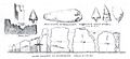 Allée couverte de Dampsmesnil dessinée par Coutil.jpg 1,321 × 604; 80 KB
-
 Allée couverte de Dampsmesnil.jpg 4,320 × 3,240; 5.49 MB
-
 Croquis de l'allée couverte de Dampsmesnil en 1894.jpg 828 × 578; 204 KB
-
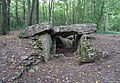 Dampsmesnil - Allée Couverte.jpg 4,078 × 2,819; 2.53 MB
-
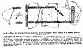 Plan de l'allée couverte de Dampsmesnil relevé par Imbert.jpg 1,184 × 690; 269 KB
-

-


