Category:Aliso Creek
Jump to navigation
Jump to search
river in the United States of America  | |||||
| Upload media | |||||
| Instance of | |||||
|---|---|---|---|---|---|
| Location | California, Pacific States Region | ||||
| Length |
| ||||
| Mouth of the watercourse | |||||
| Tributary |
| ||||
 | |||||
English: Aliso Creek is a 19-mile (31 km)-long urban stream that runs from the Santa Ana Mountains to the Pacific Ocean through Orange County, Southern California.
Subcategories
This category has the following 2 subcategories, out of 2 total.
A
Media in category "Aliso Creek"
The following 27 files are in this category, out of 27 total.
-
 Alisocreek orange map.png 500 × 500; 105 KB
-
 Alisocreekmapnew.png 693 × 800; 913 KB
-
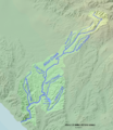
 AlisoCreekReliefMap.jpg 405 × 402; 150 KB
-
 Aliso Creek headwaters.jpg 800 × 600; 225 KB
-
 Acmapcomposite.jpg 687 × 813; 160 KB
-
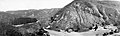
 Aliso Canyon 1918.jpg 800 × 504; 89 KB
-
 Aliso canyon bridge 1902.jpg 611 × 426; 43 KB
-
 Aliso creek 1923.jpg 716 × 349; 48 KB
-
 Aliso Creek above I-5.JPG 3,648 × 2,736; 2.38 MB
-
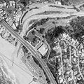
 Aliso Creek Aerial Between Laguna Beach and Laguna Niguel (52840216765).jpg 3,600 × 2,400; 4.81 MB
-
 Aliso Creek at Aliso Creek Road downstream.JPG 3,648 × 2,736; 2.35 MB
-
 Aliso Creek at AWMA Bridge March 2018.JPG 3,648 × 2,736; 3.23 MB
-
 Aliso Creek at AWMA Bridge.JPG 3,648 × 2,736; 3.23 MB
-
 Aliso Creek below Aliso Creek Road.JPG 3,648 × 2,736; 2.61 MB
-
 Aliso Creek Mouth.JPG 2,160 × 1,440; 1.39 MB
-
 Aliso Creek Rest ARea another view.jpg 3,264 × 1,836; 1.55 MB
-
 Aliso Creek Rest Area on I 5 .jpg 3,264 × 1,836; 1.06 MB
-
 Aliso Creek USACE Restoration Project Map.jpg 1,247 × 1,663; 278 KB
-
 Aliso Creek waterfall.JPG 2,048 × 1,536; 1.77 MB
-
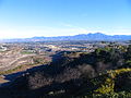 Aliso Creek with Saddleback in distance.JPG 2,048 × 1,536; 1.51 MB
-
 AlisoCanyonPanoHistorical.jpg 1,036 × 308; 102 KB
-
 Alisocreek Bridge.JPG 2,048 × 1,536; 994 KB
-
 AlisoLagoon.jpeg 200 × 200; 12 KB
-
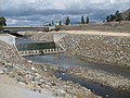
 Drop structure aliso creek.JPG 2,048 × 1,536; 1.89 MB
-
 Laguna Niguel Lake.jpg 2,816 × 2,112; 1.92 MB
-

-
 Sulphur Creek 1975.jpg 1,711 × 1,041; 314 KB


.jpg)


.jpg)
