Category:Alignement de Kerfland
Jump to navigation
Jump to search
| Object location | | View all coordinates using: OpenStreetMap |
|---|
|
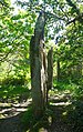
This building is classé au titre des monuments historiques de la France. It is indexed in the base Mérimée, a database of architectural heritage maintained by the French Ministry of Culture, under the reference PA00090194
|
 | |||||
| Upload media | |||||
| Instance of | |||||
|---|---|---|---|---|---|
| Location | Plomeur, Finistère, Brittany, Q88521114, Metropolitan France, France | ||||
| Heritage designation |
| ||||
 | |||||
Media in category "Alignement de Kerfland"
The following 7 files are in this category, out of 7 total.
-
 Alignement Kerfland.JPG 1,728 × 2,742; 1.89 MB
-
 Deuxième menhir Kerfland.JPG 2,304 × 3,072; 3.29 MB
-
 Menhirs de Kerfland (Plomeur) 01.jpg 3,264 × 2,448; 4.86 MB
-
 Menhirs de Kerfland (Plomeur) 02.jpg 2,448 × 3,264; 5.33 MB
-
 Menhirs de Kerfland (Plomeur) 03.jpg 2,448 × 3,264; 5.21 MB
-
 Premier menhir Kerfland.JPG 2,304 × 3,072; 3.26 MB
-
 Troisième menhir Kerfland.JPG 2,304 × 3,072; 3.27 MB

_01.jpg)
_02.jpg)
_03.jpg)

