Category:Albrechtsbrunnen (Rheinfelden AG)
Jump to navigation
Jump to search
| Object location | | View all coordinates using: OpenStreetMap |
|---|
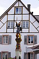
fountain in Rheinfelden in the canton of Aargau, Switzerland  | |||||
| Upload media | |||||
| Instance of | |||||
|---|---|---|---|---|---|
| Part of | |||||
| Location | Rheinfelden, Rheinfelden District, Aargau, Switzerland | ||||
| Street address |
| ||||
| Heritage designation | |||||
| Inception |
| ||||
 | |||||
Media in category "Albrechtsbrunnen (Rheinfelden AG)"
The following 3 files are in this category, out of 3 total.
-
 Albrechtsbrunnen Rheinfelden AG 20230601 0050.jpg 5,006 × 7,510; 28.62 MB
-
 Albrechtsbrunnen Rheinfelden AG 20230601 0051.jpg 5,504 × 8,256; 31.88 MB
-
 Rheinfelden AG 11.JPG 2,655 × 3,998; 4.7 MB

