Category:Albis
Jump to navigation
Jump to search
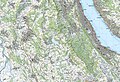
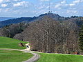
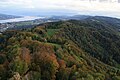
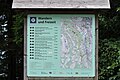
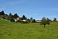
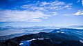
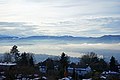
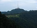
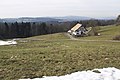
Deutsch: Der Albis ist eine Bergkette im Kanton Zürich, die von Sihlbrugg im Süden bis zur Waldegg bei Zürich im Norden über etwa 19 Kilometer parallel zur Sihl und Zürichsee verläuft. Der höchste Punkt der Kette ist der Bürglen (914.6 m.ü.M.); der bekannteste Punkt ist der Uetliberg mit einer Höhe von 870.6 m.ü.M. Die Ostflanke des Albis ist weitgehend vom Sihlwald bedeckt.
English: The Albis is a chain of hills in the canton of Zurich, Switzerland, stretching for some 19 km from Sihlbrugg in the south to Waldegg near Zurich in the north. The chain forms, among others, the border between the Affoltern and Horgen districts. The best known point is Uetliberg at 870 m, overlooking the city of Zurich. Other points of interest include the Albishorn (909m.) the Bürglen (also known as Bürglenstutz, the highest peak, 914.6m.), the Schnabelburg observation tower, Felsenegg and Felsenegg aerial tramway, the Albis Pass, the small town of Buechenegg, and the extensive woods known as Sihlwald on both sides of the river Sihl. The Sihl valley borders the Albis chain on its entire east side. On the west side, the Albis is bordered by various streams (including the en:Reppisch) and one lake, the Türlersee.
chain of hills in the Canton of Zurich, Switzerland  | |||||
| Upload media | |||||
| Instance of | |||||
|---|---|---|---|---|---|
| Location | Canton of Zürich, Switzerland | ||||
| Topographic isolation |
| ||||
| Elevation above sea level |
| ||||
 | |||||
Subcategories
This category has the following 21 subcategories, out of 21 total.
A
- Albispass (17 F)
B
- Burg Baldern (20 F)
- Burg Manegg (12 F)
- Burg Uetliburg (34 F)
F
H
K
L
- Luftseilbahn Adliswil-Felsenegg (27 F)
P
- Planetenweg Uetliberg-Felsenegg (1 P, 29 F)
R
- Ruine Schnabelburg (Albis) (11 F)
S
- Schnabellücken (6 F)
U
V
W
Media in category "Albis"
The following 74 files are in this category, out of 74 total.
-
 1111 Albis.jpg 14,000 × 9,600; 110.39 MB
-
 Albis - Balderen - Uetliberg IMG 3273.jpg 3,264 × 2,448; 2.88 MB
-
 Albis - Balderen 2010-08-17 13-43-40.JPG 4,288 × 2,848; 6.46 MB
-
 Albis - Balderen 2010-08-17 13-45-20.JPG 4,288 × 2,848; 6.4 MB
-
 Albis - Balderen 2010-08-17 13-47-06.JPG 2,848 × 4,288; 5.54 MB
-
 Albis - Balderen IMG 3279.jpg 4,288 × 2,848; 6.34 MB
-
 Albis - Balderen IMG 3281.jpg 3,264 × 2,448; 2.64 MB
-
 Albis - Balderen IMG 3282.jpg 4,288 × 2,848; 6.47 MB
-
 Albis - Feldbach - Zürichsee - Pfannenstiel - Rapperswil Lindenhof 2011-02-06 16-58-12.jpg 4,288 × 2,848; 1.56 MB
-
 Albis - Felsenegg - Balderen 2010-08-17 13-35-50.JPG 4,288 × 2,848; 6.39 MB
-
 Albis - Felsenegg - Balderen 2010-08-17 13-36-16.JPG 4,288 × 2,848; 6.39 MB
-
 Albis - Felsenegg Girstel - Baldern IMG 5309.jpg 3,118 × 2,338; 2.4 MB
-
 Albis - Felsenegg IMG 3274.jpg 3,264 × 2,448; 4.62 MB
-
 Albis - Girstel IMG 3278.jpg 3,264 × 2,448; 2.45 MB
-
 Albis - Mädikon IMG 3284.JPG 4,288 × 2,848; 4.82 MB
-
 Albis - Mädikon IMG 3287.jpg 3,074 × 2,306; 2 MB
-
 Albis - Mädikon IMG 3288.JPG 3,118 × 2,338; 3.38 MB
-
 Albis - Sihltal - Zimmerberg - Zürichsee - Uetlibergturm IMG 1580.JPG 3,888 × 2,592; 4.27 MB
-
 Albis - Uetliberg - Baldern IMG 5304.jpg 3,264 × 2,448; 2.68 MB
-
 Albis - Uetliberg - Seebad Tiefenbrunnen 2014-01-06 11-59-05 (P7700).JPG 4,000 × 3,000; 3.6 MB
-
 Albis - Uetliberg - Tiefenbrunnen 2014-01-06 11-51-02 (P7700).JPG 4,000 × 3,000; 4.17 MB
-
 Albis - Uetliberg 2012-10-29 16-12-02.JPG 4,000 × 3,000; 3.99 MB
-
 Albis - Uetliberg 2012-10-29 16-13-51.JPG 4,000 × 3,000; 4.33 MB
-
 Albis - Uetliberg Staffel IMG 5334.JPG 2,848 × 4,288; 5.22 MB
-
 Albis - Uetliberg Uto Kulm IMG 6157.JPG 4,288 × 2,848; 6.69 MB
-
 Albis - Uetliberg Uto Kulm IMG 6163.JPG 4,288 × 2,848; 3.78 MB
-
 Albis 2010-08-17 13-41-52.JPG 2,848 × 4,288; 4.63 MB
-
 Albis 2010-08-17 13-46-44.JPG 4,288 × 2,848; 2.44 MB
-
 Albis 2010-08-17 14-55-52.JPG 4,288 × 2,848; 6.33 MB
-
 Albis Bürglenstutz.JPG 2,112 × 2,816; 2.47 MB
-
 Albis F. Becker 1889.JPEG 1,537 × 966; 453 KB
-
 Albis IMG 3321.jpg 2,280 × 3,039; 3.85 MB
-
 Albis IMG 3322.JPG 3,264 × 2,448; 4.67 MB
-
 Albis passhöhe.jpg 1,050 × 700; 750 KB
-
 Albis(pass) - Felsenegg - Zürichsee - Bürkliplatz 2012-07-30 17-49-06.JPG 4,125 × 2,750; 3.18 MB
-
 Albis, felsenegg, uetliberg.jpg 4,032 × 3,024; 3.14 MB
-

-
 Alpen (115938931).jpeg 2,048 × 1,150; 497 KB
-
 Alpenpanorama vom Zürichberg mit Albis, Pilatus und Berner Alpen Dezember 2020 (5).jpg 6,000 × 4,000; 4.76 MB
-
 Alpenpanorama vom Zürichberg mit See Dezember 2020 (9).jpg 6,000 × 4,000; 5.99 MB
-
 Altartafeln von Hans Leu d.Ä. (Haus zum Rech) - linkes Limmatufer 2011-08-17 15-26-36.JPG 3,637 × 2,617; 3.08 MB
-
 Bei Albis - panoramio.jpg 2,816 × 2,120; 1.27 MB
-
 CH-NB - Zürichsee, Aussicht vom Albis gegen Zürich - Collection Gugelmann - GS-GUGE-KELLER-H-E-5.tif 6,632 × 4,340, 2 pages; 47.37 MB
-
 CH-NB - Zürichsee, Aussicht vom Albis gegen Zürich - Collection Gugelmann - GS-GUGE-KELLER-H-E-6.tif 5,551 × 2,565, 2 pages; 24.43 MB
-
 ETH-BIB-Albis-Hochwacht, von Westen-Dia 247-08358.tif 3,648 × 2,752; 9.68 MB
-
 ETH-BIB-Albis-Kamm, schmaler Grat von Südwesten mit Frau-Dia 247-08356.tif 3,008 × 3,506; 10.16 MB
-
 ETH-BIB-Albis-Kamm, schmaler Grat von Westen-Dia 247-08355.tif 3,052 × 3,565; 10.52 MB
-
 ETH-BIB-Albiskette mit Türlersee aus 1200 m-Inlandflüge-LBS MH01-002887.tif 6,491 × 3,848; 71.58 MB
-
 ETH-BIB-Schnabelburg, von Westen (Deckenschotter)-Dia 247-08357.tif 3,632 × 2,718; 9.52 MB
-
 Fallätsche Adliswil and Sihl valley 20200818.jpg 13,771 × 8,100; 83.18 MB
-
 Felsenegg - Uetliberg IMG 3244.jpg 3,140 × 2,355; 2.74 MB
-
 From Uetliberg to Felsenegg , Zurich - panoramio (148).jpg 4,272 × 2,848; 15.74 MB
-
 From Uetliberg to Felsenegg , Zurich - panoramio (149).jpg 4,272 × 2,848; 13.62 MB
-
 From Uetliberg to Felsenegg , Zurich - panoramio (151).jpg 4,272 × 2,848; 9.88 MB
-
 From Uetliberg to Felsenegg , Zurich - panoramio (152).jpg 4,272 × 2,848; 11.16 MB
-
 Gut Mädikon Mai 2023.jpeg 3,862 × 2,896; 2.15 MB
-
 Hinter Albis.JPG 1,640 × 1,220; 1.22 MB
-
 Hoehenweg Uetliberg Felsenegg - panoramio.jpg 2,035 × 1,192; 715 KB
-
 Hüttensee - Bild-01.JPG 2,048 × 1,536; 298 KB
-
 Hüttensee Panorama - 11.08.2001.jpg 5,503 × 1,259; 2.05 MB
-
 Lake of Zürich and Albis seen from Üetliberg.jpg 6,000 × 3,375; 14.36 MB
-
 Logs drying in Felsenegg - panoramio.jpg 1,600 × 1,200; 561 KB
-
 Murer Albiskette.JPG 5,105 × 2,723; 7.17 MB
-
 Nebelmeer vom Üetliberg.JPG 4,032 × 3,024; 2.34 MB
-
 Sellenbüren Richtung Üetliberg - panoramio.jpg 2,560 × 1,920; 2.17 MB
-
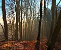 Sihlwald fog sun 20200122.jpg 4,266 × 3,521; 13.98 MB
-
 Sihlwald Schnabelburg grass.jpg 3,166 × 4,389; 18.11 MB
-
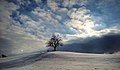
 Tree in Spring at Albis.jpg 6,000 × 3,375; 16.29 MB
-
 Zürich (25660365407).jpg 4,032 × 3,024; 2.6 MB
-
 Zürich - Üetliberg - Friedhof der Tische und Bänke.jpg 4,000 × 3,000; 10.58 MB
-
 Zürich - Üetliberg - Nebellandschaft I.jpg 6,549 × 2,700; 10.49 MB
-
 Zürich - Üetliberg - reife Äpfel.jpg 3,596 × 2,697; 7.25 MB
-
 Zürich Winter.jpg 4,000 × 3,000; 3.81 MB
-
 Zürich-Leimbach-Sihltal - Käferberg IMG 2374.JPG 3,264 × 2,448; 2.59 MB


.JPG)
.JPG)


_-_Felsenegg_-_Z%C3%BCrichsee_-_B%C3%BCrkliplatz_2012-07-30_17-49-06.JPG)


.jpeg)
.jpg)
.jpg)
_-_linkes_Limmatufer_2011-08-17_15-26-36.JPG)


.jpg)
.jpg)
.jpg)
.jpg)


.jpg)


