Category:Akebar
Jump to navigation
Jump to search
village in the United Kingdom  | |||||
| Upload media | |||||
| Instance of | |||||
|---|---|---|---|---|---|
| Location | Richmondshire, North Yorkshire, Yorkshire and the Humber, England | ||||
| Population |
| ||||
 | |||||
Media in category "Akebar"
The following 48 files are in this category, out of 48 total.
-
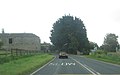
 A684 at Akebar Cottages - geograph.org.uk - 3080276.jpg 640 × 371; 61 KB
-
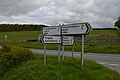
 A684 crossroads at Akebar Farm - geograph.org.uk - 3079930.jpg 640 × 398; 44 KB
-
 A684 outside Grazing Nook Farm - geograph.org.uk - 6253345.jpg 5,184 × 3,456; 7.05 MB
-
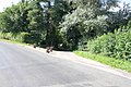
 A684 towards Bedale - geograph.org.uk - 5415097.jpg 640 × 480; 77 KB
-
 A684 towards Bedale - geograph.org.uk - 5415106.jpg 640 × 480; 59 KB
-
 A684, Akebar - geograph.org.uk - 5415096.jpg 640 × 480; 75 KB
-
 Akebar Farm - geograph.org.uk - 4484050.jpg 4,000 × 2,659; 2.49 MB
-
 Akebar Folly - geograph.org.uk - 1525215.jpg 480 × 640; 97 KB
-
 Akebar Park caravan site - geograph.org.uk - 5855205.jpg 1,024 × 768; 99 KB
-
 Alders along the beck - geograph.org.uk - 6744308.jpg 5,133 × 3,271; 3.75 MB
-
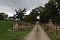 An access Lane for Akebar Caravan Park and Finghall Church - geograph.org.uk - 5565809.jpg 5,184 × 3,456; 5.31 MB
-
 Arable land near Finghall - geograph.org.uk - 5858031.jpg 1,024 × 768; 95 KB
-
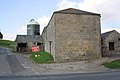
 Benchmark on building at Akebar Farm - geograph.org.uk - 3660448.jpg 683 × 1,024; 320 KB
-
 Benchmark on farmhouse at Grazing Nook - geograph.org.uk - 6469475.jpg 624 × 1,024; 252 KB
-
 Benchmark on Neesham Cottage - geograph.org.uk - 6469844.jpg 1,024 × 683; 266 KB
-
 Buildings of Akebar Farm at crossroads - geograph.org.uk - 3660461.jpg 1,024 × 683; 134 KB
-

-
 Cowslips on field edge north of Grazing Nook - geograph.org.uk - 6469505.jpg 1,024 × 683; 307 KB
-

-
 Driving Range at Wensleydale Golf Club - geograph.org.uk - 4486393.jpg 4,000 × 2,659; 2.33 MB
-
 Fields of Akebar Cotts - geograph.org.uk - 1412240.jpg 640 × 480; 51 KB
-
 FP sign by the A684 - geograph.org.uk - 5306695.jpg 4,320 × 3,240; 3.58 MB
-
 Friar's Head, Akebar Park - geograph.org.uk - 4327016.jpg 1,024 × 683; 193 KB
-
 Grazing near Grazing Nook Farm - geograph.org.uk - 5415108.jpg 640 × 480; 71 KB
-
 Grazing Nook Farm - geograph.org.uk - 4486392.jpg 4,000 × 2,660; 2.45 MB
-
 Grazing Nook Farm - geograph.org.uk - 5415103.jpg 640 × 480; 63 KB
-
 Grazing Nook Farm - geograph.org.uk - 6253334.jpg 5,184 × 3,456; 7.05 MB
-
 Grazing Nook on south side of A684 - geograph.org.uk - 6469497.jpg 1,024 × 654; 157 KB
-
 Heselton Farm - geograph.org.uk - 4484814.jpg 4,000 × 2,659; 3.06 MB
-
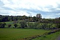
 Hillside crop field, Akebar - geograph.org.uk - 5415098.jpg 640 × 445; 74 KB
-
-
 Leeming Beck - geograph.org.uk - 6423476.jpg 5,184 × 3,888; 5.05 MB
-
 Many Ways^ - geograph.org.uk - 4484077.jpg 4,000 × 2,660; 2.58 MB
-
 Minor road, Gill Cottages - geograph.org.uk - 6617497.jpg 640 × 480; 75 KB
-
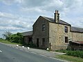
 Neesham Cottage - geograph.org.uk - 6469849.jpg 1,024 × 682; 193 KB
-
 Nichol's Stone on north side of A684 at Akebar - geograph.org.uk - 6469431.jpg 1,024 × 683; 283 KB
-
 Nichol's Stone on the A684 road at Akebar.jpg 2,700 × 1,800; 4.09 MB
-
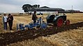 Ploughing Match by Heselton Farm - geograph.org.uk - 4167109.jpg 3,175 × 1,784; 1.48 MB
-
 Road to Hunton - geograph.org.uk - 4607228.jpg 4,320 × 3,240; 3.72 MB
-
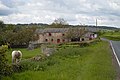
 Ruins at Akebar.jpg 640 × 480; 85 KB
-
 Sign on the Friars Head, Akebar - geograph.org.uk - 5415094.jpg 640 × 436; 63 KB
-
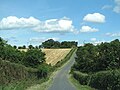
 Southbound road down Wild Hill - geograph.org.uk - 4484810.jpg 2,659 × 4,000; 2.25 MB
-
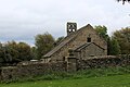 St. Andrew's Church, Finghall (1) - geograph.org.uk - 5564957.jpg 5,184 × 3,456; 7.07 MB
-
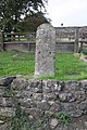 Stone on north side of A684 at Akebar - geograph.org.uk - 4327013.jpg 683 × 1,024; 261 KB
-

-
 The Friars Head, Akebar - geograph.org.uk - 5415093.jpg 640 × 480; 58 KB
-
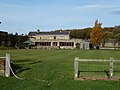 The Grey Friars Pub, Akebar - geograph.org.uk - 2143820.jpg 1,200 × 900; 446 KB
-
 Wild Hill - geograph.org.uk - 4484080.jpg 4,000 × 2,660; 2.73 MB


_-_geograph.org.uk_-_5564957.jpg)


