Category:Ajuntament de Riells i Viabrea
Jump to navigation
Jump to search
Català: Ajuntament de Riells i Viabrea
This is a category about a building listed in the Catalan heritage register as Bé Cultural d'Interès Local (BCIL) under the reference IPA-26955. |
| Object location | | View all coordinates using: OpenStreetMap |
|---|
municipal building in Riells i Viabrea, Spain  | |||||
| Upload media | |||||
| Instance of | |||||
|---|---|---|---|---|---|
| Location | Riells i Viabrea, Selva, Comarques Gironines, Catalonia | ||||
| Architectural style | |||||
| Owned by |
| ||||
| Occupant |
| ||||
| Heritage designation |
| ||||
| Elevation above sea level |
| ||||
 | |||||
Media in category "Ajuntament de Riells i Viabrea"
The following 5 files are in this category, out of 5 total.
-
 Escut d'un banc de darrera de l'Ajuntament de Riells i Viabrea.jpg 1,836 × 3,264; 3.55 MB
-
 Façana de darrera de l'Ajuntament de Riells i Viabrea.jpg 3,264 × 1,836; 2.05 MB
-
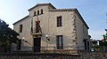 Façana de l'Ajuntament de Riells i Viabrea.jpg 3,264 × 1,836; 2.11 MB
-
 Façana lateral de l'Ajuntament de Riells i Viabrea.jpg 3,264 × 1,836; 1.91 MB
-
 Forat per mirar qui hi ha de la porta principal de l'Ajuntament de Riells i Viabrea.jpg 3,264 × 1,836; 2.02 MB


