Category:Airports in Kantō and Kōshin'etsu region
Jump to navigation
Jump to search
| Regions of Japan | |||
|---|---|---|---|
| Hokkaido Tōhoku · Kantō · Chūbu · Kansai · Chūgoku Shikoku Kyūshū and Okinawa |

| ||
- English: Airports in Kantō and Kōshin'etsu region (en:Tokyo, en:Kanagawa Prefecture, en:Saitama Prefecture, en:Chiba Prefecture, en:Ibaraki Prefecture, en:Gunma Prefecture, en:Tochigi Prefecture, en:Yamanashi Prefecture, en:Nagano Prefecture, and en:Niigata Prefecture).
Wikimedia category | |||||
| Upload media | |||||
| Instance of | |||||
|---|---|---|---|---|---|
| |||||
Subcategories
This category has the following 10 subcategories, out of 10 total.
A
- Ami Airfield (5 F)
H
- Honda Airport (12 F)
I
M
- Matsumoto Airport (23 F)
- Miyakejima Airport (5 F)
N
R
- Ryūgasaki Airfield (10 F)
S
- Sado Airport (14 F)
Media in category "Airports in Kantō and Kōshin'etsu region"
The following 22 files are in this category, out of 22 total.
-
 20040306OnishiAirport-CIMG0015.JPG 1,280 × 960; 414 KB
-
 Ami (1258416848).jpg 3,008 × 2,000; 1.56 MB
-
 Gunma heliport.jpg 3,648 × 2,736; 5.72 MB
-
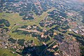
 Honda Airport Aerial photograph.jpg 4,354 × 2,419; 6.51 MB
-
 Kashiwa Airfield.png 1,164 × 958; 300 KB
-
 Kashiwa airfield.png 963 × 586; 150 KB
-
 Kawajima Honda Airport Aerial photograph.1990.jpg 3,159 × 2,287; 6.32 MB
-
 Menuma.gliderport.jpg 3,648 × 2,736; 5.16 MB
-
 Miyakejima Airport Aerial photograph.jpg 2,997 × 2,166; 1.59 MB
-
 Onishi privately owned runwey Aerial photograph.1986.jpg 2,431 × 1,761; 3.45 MB
-
 Ootone airfield aerial photograph.jpg 3,648 × 2,736; 7.86 MB
-
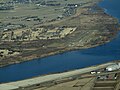 Ootone.airfield.aerialshoot.jpg 3,648 × 2,736; 3.62 MB
-
 Ootone.airport.jpg 3,840 × 2,160; 3.26 MB
-
 Otone Airfield Aerial photograph.jpg 2,557 × 1,846; 1.02 MB
-
 Otone Airfield Aerial photograph2010.jpg 2,413 × 1,832; 2.7 MB
-
 Otone-hikouzyou.JPG 3,648 × 1,216; 1.85 MB
-
 Shinonome runwey Aerial photograph.1974.jpg 3,465 × 2,500; 3.13 MB
-
 Shinonome runwey Aerial photograph.1979.jpg 2,727 × 1,966; 3.44 MB
-
 大利根飛行場 - panoramio.jpg 3,216 × 4,288; 4.86 MB
-
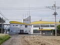
 大日本帝国陸軍東部第105部隊営門跡.png 1,920 × 1,080; 2.61 MB
-
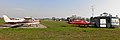
 大西飛行場(館林市) 管制塔付近.jpg 2,448 × 1,836; 1.07 MB
-
 関東地方の空港等周辺空域.png 739 × 553; 207 KB

.jpg)


_%E7%AE%A1%E5%88%B6%E5%A1%94%E4%BB%98%E8%BF%91.jpg)
