Category:Aerial photographs of Weißenfels
Jump to navigation
Jump to search
Deutsch: Luftbilder von Weißenfels sowie von Ortsteilen der Stadt.
English: Aerial photographs of Weißenfels (Burgenlandkreis, Saxony-Anhalt, Germany), including incorporated villages.
Media in category "Aerial photographs of Weißenfels"
The following 14 files are in this category, out of 14 total.
-
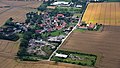
 Großkorbetha, Kleinkorbetha 001.jpg 6,016 × 3,384; 7.85 MB
-
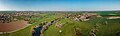
 Lützen Oeglitzsch Aerial Pan.jpg 10,897 × 3,380; 25.11 MB
-
 Pettstädt 001.jpg 6,016 × 3,384; 8.43 MB
-
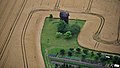 Pettstädt 003, Windmühle.jpg 6,016 × 3,384; 9.86 MB
-
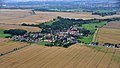
 Schkortleben 001.jpg 6,016 × 3,384; 8.82 MB
-
 Schkortleben, Kriechau 001.jpg 6,016 × 3,384; 9.09 MB
-
 Storkau (Weißenfels) 001.jpg 6,016 × 3,384; 8.04 MB
-
 Storkau (Weißenfels) Obschütz 001.jpg 6,016 × 3,384; 6.65 MB
-
 Tagewerben 001.jpg 6,016 × 3,384; 7.74 MB
-
 Tagewerben Nähe 003, Wasserturm.jpg 6,016 × 3,384; 9.32 MB
-
 Weissenfels Luftbild.jpg 1,024 × 768; 212 KB
-
 Weißenfels Kleinkorbetha Aerial alt.jpg 3,900 × 2,148; 5.9 MB
-
 Weißenfels Kleinkorbetha Aerial Pan.jpg 10,645 × 3,156; 24.01 MB
-
 Weißenfels Kleinkorbetha Aerial.jpg 3,942 × 2,167; 6 MB


_001.jpg)
_Obsch%C3%BCtz_001.jpg)


