Category:Aerial photographs of Weißenberg
Jump to navigation
Jump to search
Urban municipalities:
Rural municipalities:
Burkau · Crostwitz · Doberschau-Gaußig · Elsterheide · Großdubrau · Großpostwitz · Göda · Haselbachtal · Hochkirch · Kubschütz · Königswartha · Laußnitz · Lichtenberg · Lohsa · Malschwitz · Nebelschütz · Neschwitz · Ottendorf-Okrilla · Oßling · Panschwitz-Kuckau · Puschwitz · Radibor · Ralbitz-Rosenthal · Räckelwitz · Schwepnitz · Spreetal · Wachau
Former municipalities:
Deutsch: Luftbilder der Stadt Weißenberg
Hornjoserbsce: Powětrowe wobrazy města Wósporka
Media in category "Aerial photographs of Weißenberg"
The following 23 files are in this category, out of 23 total.
-
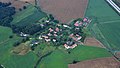 Cortnitz 001.jpg 6,016 × 3,384; 8.44 MB
-
 Gröditz (Weißenberg) 001.jpg 6,016 × 3,384; 8.75 MB
-
 Malschwitz Brießnitz Aerial Pan.jpg 8,836 × 3,121; 19.62 MB
-
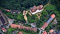 Schloss Gröditz (Weißenberg) 004.jpg 6,016 × 3,384; 9.42 MB
-
 Weicha (Weißenberg) 001.jpg 6,016 × 3,384; 8.23 MB
-
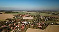
 Weißenberg 001.jpg 6,016 × 3,384; 9.53 MB
-
 Weißenberg 006.jpg 6,016 × 3,384; 8.69 MB
-
 Weißenberg Cortnitz Aerial.jpg 4,000 × 2,250; 6.75 MB
-
 Weißenberg Grube Aerial Pan.jpg 9,227 × 3,688; 24.93 MB
-
 Weißenberg Grube Aerial.jpg 3,909 × 2,140; 6.95 MB
-
 Weißenberg Gröditz Aerial alt.jpg 3,893 × 2,183; 7.36 MB
-
 Weißenberg Gröditz Aerial Pan.jpg 7,558 × 3,329; 17.64 MB
-
 Weißenberg Gröditz Aerial.jpg 3,896 × 2,127; 6.78 MB
-
 Weißenberg Maltitz Aerial Pan.jpg 8,862 × 3,537; 23.85 MB
-
 Weißenberg Maltitz Aerial.jpg 3,921 × 2,123; 6.28 MB
-
 Weißenberg Nostitz Aerial alt.jpg 3,904 × 2,144; 6.29 MB
-
 Weißenberg Nostitz Aerial Pan alt.jpg 7,507 × 3,754; 20.24 MB
-
 Weißenberg Nostitz Aerial Pan.jpg 7,944 × 3,513; 21.05 MB
-
 Weißenberg Nostitz Aerial.jpg 3,908 × 2,140; 6.39 MB
-
 Weißenberg Spittel Aerial Pan.jpg 7,541 × 3,671; 20.73 MB
-
 Weißenberg Spittel Aerial.jpg 3,921 × 2,148; 7.52 MB
-
 Weißenberg Wasserkretscham Aerial Pan.jpg 9,381 × 3,849; 30.53 MB
-
 Weißenberg Wasserkretscham Aerial.jpg 3,921 × 2,148; 6.32 MB

_001.jpg)
_004.jpg)
_001.jpg)


