Category:Aerial photographs of Taipei
Jump to navigation
Jump to search
English: The aerial photographs of Taipei.
日本語: 台北の航空写真。
中文(臺灣):臺北的空拍照。
Media in category "Aerial photographs of Taipei"
The following 200 files are in this category, out of 255 total.
(previous page) (next page)-
 1945年美軍航測影像中的日式宿舍群.jpg 714 × 713; 128 KB
-
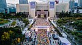 2021年12月30日 臺北馬拉松 臺北市政府.jpg 2,400 × 1,350; 995 KB
-
 623遊行 02(調色).jpg 2,048 × 1,152; 2.92 MB
-
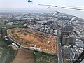
 Above the Wasteland (3619237380).jpg 900 × 600; 89 KB
-
 Aerial panorama of Taipei city's west side facing the Tamsui River.jpg 8,192 × 3,306; 8.71 MB
-
 Aerial panorama of Taipei City's west.jpg 8,192 × 3,308; 9.08 MB
-
 Aerial panorama of Taipei's west from the perspective of Tamsui River.jpg 8,192 × 3,318; 8.53 MB
-
 Aerial photograph of CTS Media Park 20200621.jpg 2,160 × 1,620; 3.19 MB
-
 Aerial photograph of downtown Taihoku, Formosa 1932.jpg 2,048 × 1,365; 746 KB
-
 Aerial photograph of downtown Taihoku, Formosa.jpg 1,728 × 1,247; 926 KB
-
 Aerial photograph of Ming Yao Department Store 20200524.jpg 2,160 × 1,620; 2.94 MB
-
 Aerial photograph of Nanman Building 2023.jpg 4,000 × 3,000; 2.34 MB
-
 Aerial photograph of the Taihoku Railway Station and its surroundings circa 1930.jpg 3,211 × 1,973; 9.02 MB
-
 Aerial photograph of Toad Mountain and Huan Min Village 20230113.jpg 4,048 × 2,272; 1.54 MB
-
 Aerial photographs of Dihua Street.jpg 1,024 × 575; 156 KB
-
 Beitou Heart Village Aerial photography.jpg 1,707 × 960; 610 KB
-

-
 Beitou Hot Spring Museum and TPL Beitou Branch aerial photograph 20210818.jpg 1,920 × 1,280; 1.64 MB
-
 Construction of the Taipei Dome 20200621.jpg 2,160 × 1,620; 2.8 MB
-
 CTBC Financial Park 20110917.jpg 856 × 480; 192 KB
-
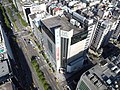
 Dunnan Financial Building Aerial photograph 01.jpg 2,160 × 1,620; 2.91 MB
-
 Dunnan Financial Building Aerial photograph 02.jpg 2,160 × 1,620; 2.6 MB
-
 Fude Cemetery Aerialphoto.jpg 5,472 × 3,648; 4.31 MB
-

-

-

-

-

-

-
-

-

-
-

-

-

-
-
-

-

-

-

-

-

-

-

-
-

-

-

-

-

-
-

-
-

-

-

-

-

-

-
-
-

-
-
-

-

-
-
-
-
-

-

-
-

-
-

-

-

-

-

-

-

-
-

-
-

-

-
-

-

-

-

-

-
-
-

-

-

-
-

-

-

-

-

-
-

-
-
-

-
-

-
-

-

-

-

-

-
-
-

-

-
-
-

-

-

-

-

-

-

-

-
 MiNe-MM 100-0479RG.jpg 2,160 × 1,620; 3.04 MB
-
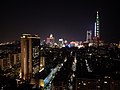 Night skyline of Taipei 2020.jpg 2,160 × 1,620; 2.15 MB
-
 North Gate Square.jpg 1,024 × 683; 152 KB
-
 Ren'ai Dunhua traffic circle 202006.jpg 2,160 × 1,620; 2.67 MB
-
 Renai Road Sec 4 Aerial.jpg 2,160 × 1,620; 2.74 MB
-
 Renai Roundabout at night from the air.jpg 2,160 × 1,620; 2.71 MB
-
 Space Radar Image of Taiwan.jpg 600 × 395; 50 KB
-
 Taihoku Air Raid 1945.jpg 1,365 × 1,743; 840 KB
-
 Taipei 101 viewed from Guangfu South Road 20200621.jpg 2,160 × 1,620; 2.6 MB
-
 Taipei Air Station Taipei Taiwan Aerial View 1968.jpg 2,760 × 2,240; 2.82 MB
-
 Taipei Botanical Garden Aerial photo.jpg 1,231 × 923; 417 KB
-
 Taipei City Xing Yan Social Welfare Services Building (cropped).jpg 1,600 × 1,000; 359 KB
-
 Taipei City Xing Yan Social Welfare Services Building.jpg 1,920 × 1,280; 517 KB
-
 Taipei Guangci Charity Park 2024.jpg 1,000 × 666; 911 KB
-
 Taipei Guangci Park Aerial photo (cropped).jpg 2,422 × 1,676; 789 KB
-
 Taipei Guangci Park Aerial photo.jpg 3,503 × 1,926; 1.16 MB
-
 Taipei Huai Ai Funeral Parlor Aerialphoto (cropped).jpg 3,804 × 2,935; 2.4 MB
-
 Taipei Huai Ai Funeral Parlor Aerialphoto.jpg 5,280 × 2,970; 3.35 MB
-
 Taipei Kuang Tzu Po Ai Park.jpg 1,280 × 893; 344 KB
-
 Taipei Municipal Renai Junior High School Aerial photo.jpg 2,160 × 1,620; 2.95 MB
-
 Taipei Municipal Yongchun Senior High School 2020 (cropped).jpg 2,508 × 1,498; 1.01 MB
-
 Taipei Municipal Yongchun Senior High School 2020.jpg 5,464 × 3,070; 3.4 MB
-

-
 Taipei Skyline viewed from Guangfu South Road 20200621.jpg 2,160 × 1,620; 2.77 MB
-
 Taipei Taihoku Oveview 06.jpg 773 × 494; 166 KB
-
 Taipei, Taiwan.JPG 639 × 435; 71 KB
-
 Taiwan Exposition, area 1, Taihoku, 1935.jpg 1,213 × 892; 575 KB
-
 Tianmu Baseball Stadium aerial photograph.jpg 4,000 × 3,000; 2.61 MB
-
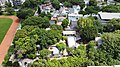
 Treasure Hill 20181005 (cropped).jpg 7,167 × 4,761; 8.98 MB
-
 Treasure Hill 20181005.jpg 8,447 × 5,631; 11.93 MB
-

-
-
-

-
-
-

-

-

-

-

-

-

-

-
-

-

-

-

-
-
-
-

-

-

-

-
-

-
-

-
-

-

-

-
-

-


.jpg)


.jpg)


.jpg)


.jpg)

.jpg)


.jpg)


.jpg)


