Category:Aerial photographs of Salzlandkreis
Jump to navigation
Jump to search
Districts of Saxony-Anhalt:
Urban districts (cities):
Media in category "Aerial photographs of Salzlandkreis"
The following 60 files are in this category, out of 60 total.
-
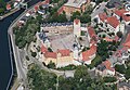 Aerial image of Schloss Bernburg (view from the south).jpg 4,200 × 2,900; 5.51 MB
-
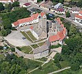 Aerial image of Schloss Plötzkau (view from the south).jpg 3,000 × 2,700; 4.04 MB
-
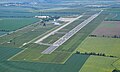
 Aerial image of the Aschersleben airfield.jpg 4,500 × 3,200; 4.65 MB
-
 Aerial image of the Hoym airfield.jpg 4,300 × 3,300; 4.56 MB
-
 Aerial image of the Klein Mühlingen airfield.jpg 4,400 × 2,900; 2.98 MB
-
 Aerial image of the Magdeburg-Cochstedt airport.jpg 5,000 × 3,000; 3.75 MB
-
 Aerial image of the Schönebeck-Zackmünde airfield.jpg 4,200 × 3,000; 3.38 MB
-
 Biere 001.JPG 4,032 × 2,268; 5.02 MB
-
 Borne (bei Staßfurt) 001.JPG 4,032 × 2,268; 5.01 MB
-
 KLG 0056 Calbe (Saale).jpg 6,016 × 3,384; 9.3 MB
-
 Standort Calbe.jpg 4,142 × 3,107; 10.39 MB
-
 Egeln 004b, Wasserturm.jpg 3,024 × 1,704; 2.83 MB
-
 Eggersdorf (Bördeland) 001.JPG 4,032 × 2,268; 4.9 MB
-
 Elbenau 1.jpg 3,840 × 2,160; 5.21 MB
-
 Elbenau 2.jpg 3,840 × 2,160; 4.3 MB
-
 Erinnerungsgarten Zentralfriedhof Aschersleben.jpg 2,631 × 1,819; 6.65 MB
-
 Frose - panoramio.jpg 4,000 × 3,000; 2.89 MB
-
 Gnadau 001.JPG 4,032 × 2,272; 4.95 MB
-
 Gradierwerk Schönebeck (Elbe).jpg 1,712 × 1,368; 346 KB
-
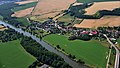
 Großmühlingen aus der Luft.jpg 2,720 × 1,530; 3.69 MB
-
 Hoym 001.JPG 4,032 × 2,272; 5.24 MB
-
 Kleinmühlingen 001.jpg 6,016 × 3,384; 9.41 MB
-
 Kleinmühlingen 004, Windmühle.jpg 6,016 × 3,384; 9.21 MB
-
 Kleinmühlingen 008, Flugplatz.jpg 6,016 × 3,384; 7.46 MB
-
 KLG 0032 Tarthun.jpg 6,016 × 3,384; 8.47 MB
-
 KLG 0034 Unseburg.jpg 6,016 × 3,384; 8.55 MB
-
 KLG 0049 Atzendorf (Staßfurt).jpg 6,016 × 3,384; 8.47 MB
-
 KLG 0050 Förderstedt.jpg 6,016 × 3,384; 8.1 MB
-
 KLG 0051 Üllnitz.jpg 6,016 × 3,384; 9.02 MB
-
 KLG 0052 Brumby (Staßfurt).jpg 6,016 × 3,384; 9.25 MB
-
 KLG 0058 Schwarz (Calbe).jpg 6,016 × 3,384; 8.99 MB
-
 KLG 0059 Zuchau.jpg 6,016 × 3,384; 8.7 MB
-
 Kloster Nienburg 005.jpg 6,016 × 3,384; 8.6 MB
-
 Kloster Nienburg 006.jpg 6,016 × 3,384; 8.22 MB
-
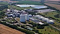 Könnern 001, Industriegebiet Nord, Pfeifer u. Langen.jpg 6,016 × 3,384; 7.94 MB
-
 Könnern 001.jpg 6,016 × 3,384; 8.6 MB
-
 Könnern DJI 20240621 0011.JPG 4,032 × 2,268; 5.72 MB
-
 Lebendorf, Bebitz 001.jpg 6,016 × 3,384; 8.89 MB
-
 Nachterstedt 001.JPG 4,032 × 2,272; 5.21 MB
-
 Nelben 001.jpg 6,016 × 3,384; 7.87 MB
-
 Nelben DJI 20240621 0007.JPG 2,664 × 981; 1.89 MB
-
 Nienburg (Saale) 001.jpg 6,016 × 3,384; 8.75 MB
-
 Peißen 001.jpg 6,016 × 3,384; 8.73 MB
-
 Schloss Barby Luftbild.jpg 4,000 × 3,000; 2.42 MB
-
 Schloss Bernburg Luftbild 2.jpg 3,702 × 2,777; 4.11 MB
-
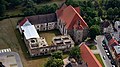
 Schloss Bernburg Luftbild.jpg 3,831 × 2,876; 2.49 MB
-
 Schloss Bernburg.jpg 4,000 × 3,000; 2.65 MB
-
 Schloss Hoym 001.JPG 4,032 × 2,268; 5.19 MB
-
 Unseburg Nähe 002b.jpg 4,512 × 2,538; 5 MB
-
 Vollständige Übersicht.JPG 2,592 × 1,944; 2.15 MB
-
 Wasserburg Egeln 004.JPG 4,032 × 2,272; 5.21 MB
-
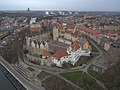
 Wasserburg Egeln 009.jpg 6,016 × 3,384; 8.87 MB
-
 Wasserburg Egeln Luftbild 2.jpg 4,000 × 3,000; 2.34 MB
-
 Wasserburg Egeln Luftbild 3.jpg 4,000 × 3,000; 3.06 MB
-
 Wasserburg Egeln Luftbild.jpg 4,000 × 3,000; 2.86 MB
-
 Weinberg bei Zens.jpg 4,000 × 3,000; 10.67 MB
-
 Wolmirsleben 001.JPG 4,032 × 2,268; 4.99 MB
-
 Wolmirsleben 003b, Wasserturm.jpg 3,024 × 1,701; 2.76 MB
-
 Zens aus der Luft.jpg 3,600 × 2,400; 6.44 MB
-
 Zickeritz, Brucke 002.jpg 6,016 × 3,384; 9.41 MB
.jpg)
.jpg)


_001.JPG)
.jpg)


_001.JPG)


.jpg)


.jpg)


.jpg)
.jpg)


_001.jpg)


