Category:Aerial photographs of Northern Ireland
Jump to navigation
Jump to search
Constituent countries of the United Kingdom: England · Northern Ireland · Scotland · Wales – British Crown dependencies: Bailiwick of Guernsey · Isle of Man · Jersey
British overseas territories: Anguilla · Bermuda · British Indian Ocean Territory · British Virgin Islands · Cayman Islands · Falkland Islands · Gibraltar · Turks and Caicos Islands
British overseas territories: Anguilla · Bermuda · British Indian Ocean Territory · British Virgin Islands · Cayman Islands · Falkland Islands · Gibraltar · Turks and Caicos Islands
Subcategories
This category has the following 7 subcategories, out of 7 total.
A
B
D
T
Media in category "Aerial photographs of Northern Ireland"
The following 38 files are in this category, out of 38 total.
-
 1500 ft High! above Larne Town - geograph.org.uk - 55258.jpg 640 × 426; 157 KB
-
 Artificial Island, Magheramourne - geograph.org.uk - 345951.jpg 640 × 426; 200 KB
-
 Ballymagorry - geograph.org.uk - 306284.jpg 640 × 480; 183 KB
-
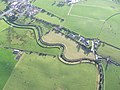
 Blackrock Bridge - geograph.org.uk - 467291.jpg 640 × 480; 96 KB
-
 Cross Bank from the Air - geograph.org.uk - 594989.jpg 640 × 480; 37 KB
-
 Enniskillen from the air at 2000ft - geograph.org.uk - 611018.jpg 640 × 480; 105 KB
-
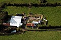 Farmhouse and Yard, Islandmagee - geograph.org.uk - 345993.jpg 640 × 426; 140 KB
-
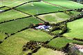 Farmhouse Islandmagee - geograph.org.uk - 345936.jpg 640 × 426; 159 KB
-
 Industrial Estate Omagh - geograph.org.uk - 305936.jpg 640 × 480; 311 KB
-
 Innismore Hall, Derrybrusk - geograph.org.uk - 572310.jpg 640 × 352; 74 KB
-
 Islands in Strangford Lough - geograph.org.uk - 3930320.jpg 3,264 × 2,448; 3.03 MB
-
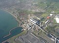 Kilroot Power Station from the air - geograph.org.uk - 4702635.jpg 3,000 × 2,228; 1.43 MB
-
 Larne Lough from the air - geograph.org.uk - 6346152.jpg 995 × 1,024; 334 KB
-
 Loughmuck, Omagh - geograph.org.uk - 304317.jpg 640 × 480; 73 KB
-
 Magheramourne Cement Works - geograph.org.uk - 345897.jpg 640 × 426; 107 KB
-
 Main Street Dunloy - geograph.org.uk - 825874.jpg 640 × 480; 118 KB
-
 Mourne Valley - geograph.org.uk - 304299.jpg 640 × 480; 46 KB
-
 Omagh - geograph.org.uk - 304296.jpg 640 × 480; 49 KB
-
 Omagh, from the East - geograph.org.uk - 310323.jpg 639 × 480; 77 KB
-
 Omagh, from the south - geograph.org.uk - 310347.jpg 639 × 480; 97 KB
-
 Omagh- South - geograph.org.uk - 312644.jpg 639 × 480; 83 KB
-
 Peace bridge Derry Londonderry.png 1,920 × 1,080; 2.83 MB
-
 Rathmullen Point and Minerstown from the air - geograph.org.uk - 6349202.jpg 1,024 × 768; 280 KB
-
 Stone Bridge - geograph.org.uk - 556870.jpg 640 × 480; 82 KB
-
 Terex Finlay Factory Omagh - geograph.org.uk - 556878.jpg 640 × 480; 99 KB
-

-
 The Interconnector Islandmagee - geograph.org.uk - 345944.jpg 640 × 426; 152 KB
-
 Titanic Quarter aerial (1).jpg 938 × 1,250; 1.64 MB
-
 Titanic Quarter aerial (2).jpg 1,250 × 938; 1.64 MB
-
 Titanic Quarter aerial (3).jpg 1,250 × 938; 1.46 MB
-
 Titanic Quarter aerial (4).jpg 1,250 × 938; 1.44 MB
-
 Tyrone and Fermanagh Hospital, Omagh - geograph.org.uk - 304337.jpg 639 × 480; 86 KB
-
 Tyrone and Fermanagh Hospital, Omagh - geograph.org.uk - 310332.jpg 639 × 480; 77 KB
-
 Tyrone and Fermanagh Hospital, Omagh - geograph.org.uk - 310341.jpg 639 × 480; 87 KB
-
 Wrong Airport - geograph.org.uk - 594966.jpg 640 × 480; 54 KB
-
 A5 Near Omagh - geograph.org.uk - 341140.jpg 640 × 480; 127 KB
-
 Country Lane - geograph.org.uk - 341131.jpg 640 × 480; 104 KB
-
 Rivermouth Near Carrickheugh - geograph.org.uk - 593841.jpg 640 × 480; 35 KB


.jpg)
.jpg)
.jpg)
.jpg)


