Category:Aerial photographs of Lüderitz
Jump to navigation
Jump to search
Media in category "Aerial photographs of Lüderitz"
The following 14 files are in this category, out of 14 total.
-
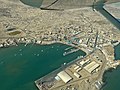
 Aerial view of Lüderitz (2017).jpg 4,928 × 3,264; 7.69 MB
-
 Frotamerica 2018.jpg 5,472 × 3,648; 8.28 MB
-
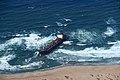 FrotamericaShipWreck.jpg 5,472 × 3,648; 7.5 MB
-
 Hafen Lüderitz (2016).jpg 4,896 × 3,264; 4.66 MB
-
 Hafen Lüderitz.jpg 5,472 × 3,648; 7.88 MB
-
 Luderitz bird's eye view.jpg 2,024 × 1,518; 2.53 MB
-
 Lüderitz Robert Harbour and Islands, Namibia (2017).jpg 4,679 × 3,066; 6.66 MB
-
 Lüderitzbucht aerial.jpg 600 × 399; 61 KB
-
 Nationalstraße B4 bei Lüderitz (2017).jpg 4,441 × 2,842; 5.09 MB
-
 Nationalstraße B4 nach Lüderitz, Namibia (2017).jpg 4,928 × 3,264; 8.2 MB
-
 Robert Harbour, Redford Bay and Isles of Lüderitz (Namibia).jpg 4,928 × 3,264; 7.37 MB
-
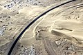 Versandete Bahnstrecke bei Lüderitz Mai 2018.jpg 6,000 × 4,000; 12.75 MB
-
 Vertical Lüderitz, Namibia (2015).jpg 5,472 × 3,648; 14.04 MB
-
 Windkraftwerk Lüderitz.jpg 5,472 × 3,648; 10.44 MB
.jpg)


.jpg)


.jpg)

.jpg)
.jpg)
.jpg)

.jpg)
